
Westwijk Rooted
Westwijk, an icon neighborhood of post war urbanism, needs renewal. Both the original housing stock and the public space are outdated. The clear urban layout designed by Willem van Tijen offers a good basis to further draw upon. At the same time we will have to break with some of the original principles. We have to move form tabula rasa to tabula scripta and from a separation to combination. More specifically, this means that the relation between the residents (and their houses) and the ground has to radically change and that both the housing stock and the public space has to become more attractive, diverse and sustainable.
Westwijk Rooted is about a neighborhood that is linked to its reconstruction past, its wet soil, the adjacent polder landscape, the new metro station and of course with existing and new residents. A new ground level based on the wet soil condition forms the landscape framework of the plan. It makes the neighborhood climate-proof, water-resilient and biodiverse. At the same time, it creates the ideal conditions for attractive new living environments that are anchored in the ground level.
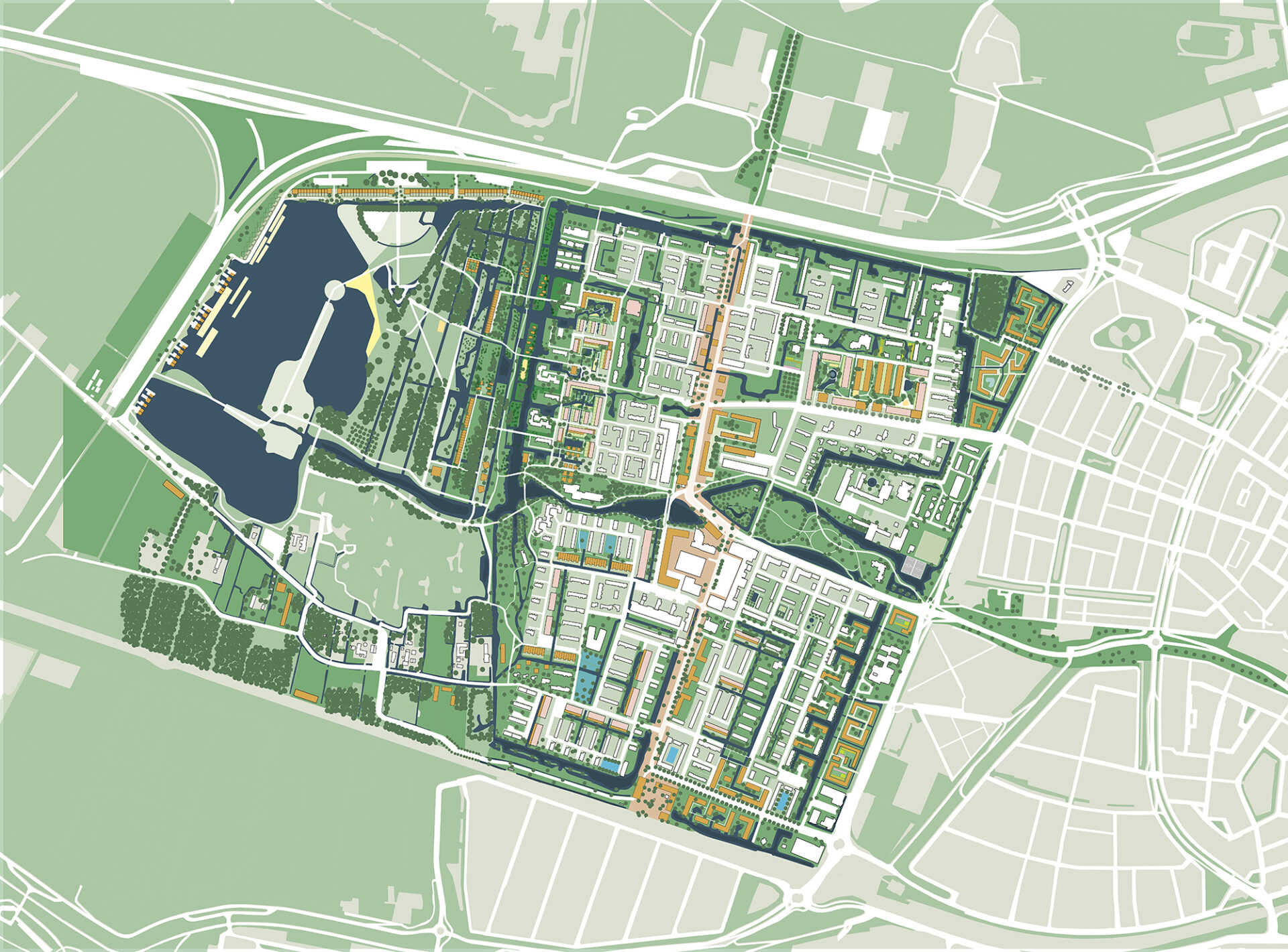
To help Westwijk and its residents take root, we use the following five strategies:
From floodings … to a climate-adaptive living environment
Westwijk was built in the 1950s on a thick layer of sand without any relation to the peaty ground. By excavating the sand layer in the public space, adding much more surface water to the neighborhood and raising the Krabbeplas area in strategic places, attractive and climate-adaptive residential environments with limited subsidence are created.
From isolated … to connected
In addition to the interweaving of Westwijk with the Krabbeplas recreation area, the connection with the new metro station must also be strengthened. What is needed is an entrance square, a station development with housing and an improvement of the north-south axis that also establishes the link with the Broekpolder.
From skimpy green … to green with value
By better attuning the greenery to the water-rich soil condition, less maintenance will be required and the ecological quality will increase. A greater biodiversity goes hand in hand with a more recreational qualities and attractive walking routes. The green can also be used functionally due to its water purifying capabilities.
From uniform housing … to a diverse mix
Our plan focuses on a varied housing stock with an emphasis on more ground-based housing in the private sector. In Van Tijen’s urban stamps, the necessary adaptions because of the energy transition are used to realize a combination of demolition, new construction, renovation and transformation. In the new development locations on the edges of the neighborhood, a combination is also being sought between homes for young and old, both in the private sector and in social rent sector.
From social isolation … to communities
We are committed to stimulating communities. Communities consisting of residents with a mix of economic strength, age and family situation. Communities that feel connected to their immediate living environment. In addition to the housing supply, the design of the public space plays a decisive role in the creation of these communities.
The deployment of the various strategies provides the ambition map for the Nieuwe Westwijk. This map is not a blueprint, but a dot on the horizon to work towards. Based on two prototypical case studies, we show how this ambition can be put into practice.

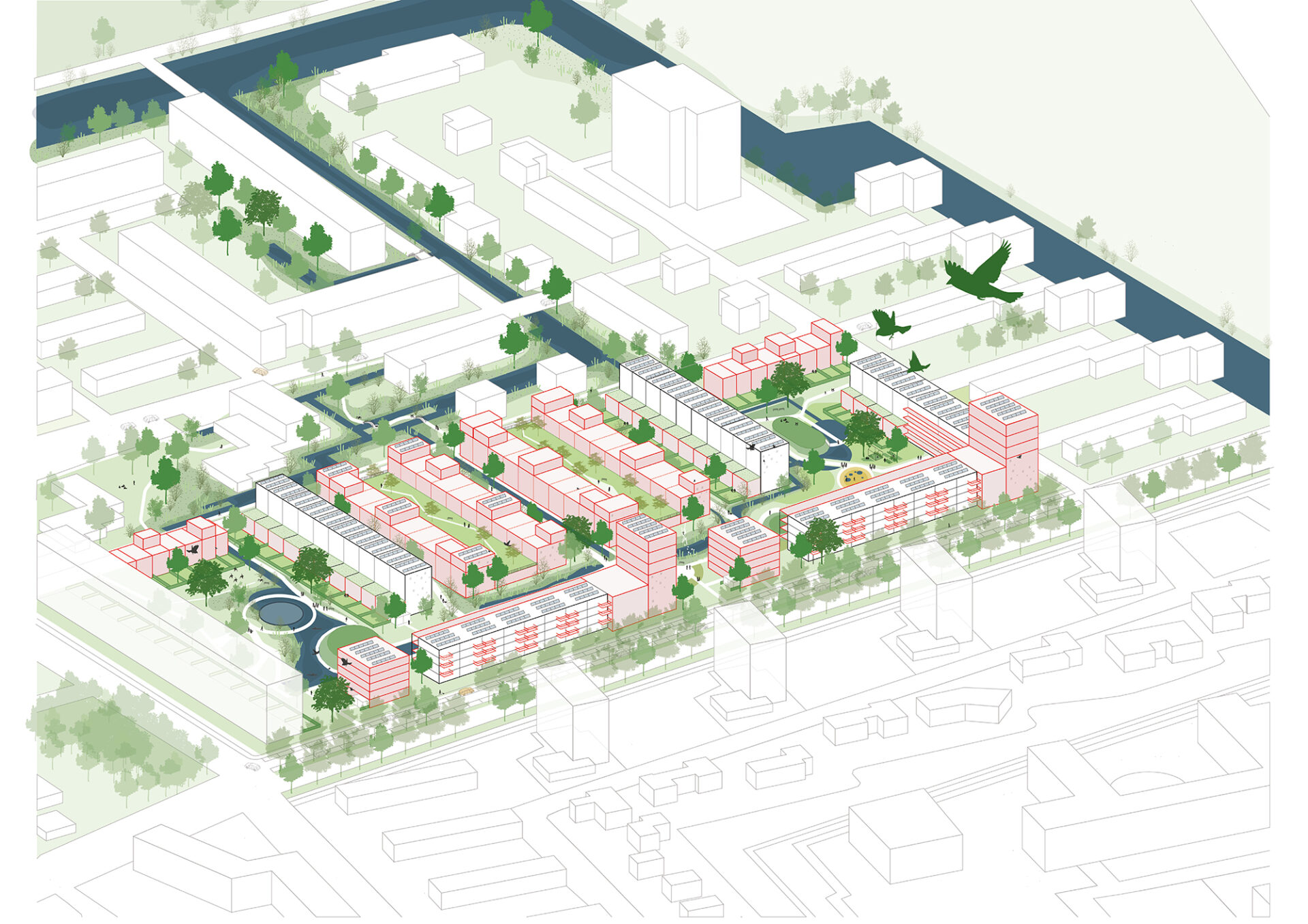
Wetering: Core of the neighborhood
In the core of the neighborhood, stamps with one-sidedly oriented residential blocks and an indefinable public space currently dominate the image. By demolishing part of the residential blocks and replacing them with ground-level homes and transforming some of the blocks into homes for families and the elderly, a rich mix of housing types is created. In the public space, a climate-robust, connective and biodiverse outdoor space is created by cutting roads, excavating soil and connecting waters. In the south a more urban wall is being created by the addition of life-course-proof apartment buildings.


Lage Weide: Connection with the landscape
The current situation is characterized by a hard division between landscape and neighborhood. They are separated from each other by a wide watercourse without bridge connections. Our approach is to interweave landscape and neighborhood and to connect both with the natural wet soil condition. This creates a connecting water landscape that forms the basis for new living environments. The current homogeneous housing stock in the stamps is supplemented with new housing typologies with an emphasis on ground-based family homes. To this end, both new constructions (after demolition) and transformation of the existing flats are applied. In order to create more water, ground is excavated. Excavated soil is used to create mounds for a mix of recreation and housing in the landscape.


Ring around Krabbeplas
In order to co-finance the large-scale transformation of the public area of Westwijk in particular, we see an opportunity to make a limited number of specific forms of housing possible in – and especially around – the Krabbeplas area. The condition is that living remains subordinate to recreation and that the residential buildings make a significant financial contribution to the transition of Westwijk. In addition to the residential enclaves located on mounds in the transition area between landscape and neighborhood, we are also providing noise barrier houses along the A20 in the north. Together with water houses on the west bank of the Krabbeplas and a series of CPO residential areas on the southern polder ribbon (Zuidbuurt), a new route around of Krabbeplas is created.


Credits
- Year 2020-
- Location Vlaardingen
- Status ongoing
-
Prizes
- 1st prize "Panorama Lokaal" competition organized by the Dutch government architect
-
Team
- Thijs van Bijsterveldt
- Oana Rades
- Harm Timmermans
- Philip de Klerk
- Karolina Kowalczyk
- Ema Dunkić
-
Partner
Flux landscape architecture, in collaboration with Acaccia Water, Bureau Stadsnatuur en Except Integrated Sustainability