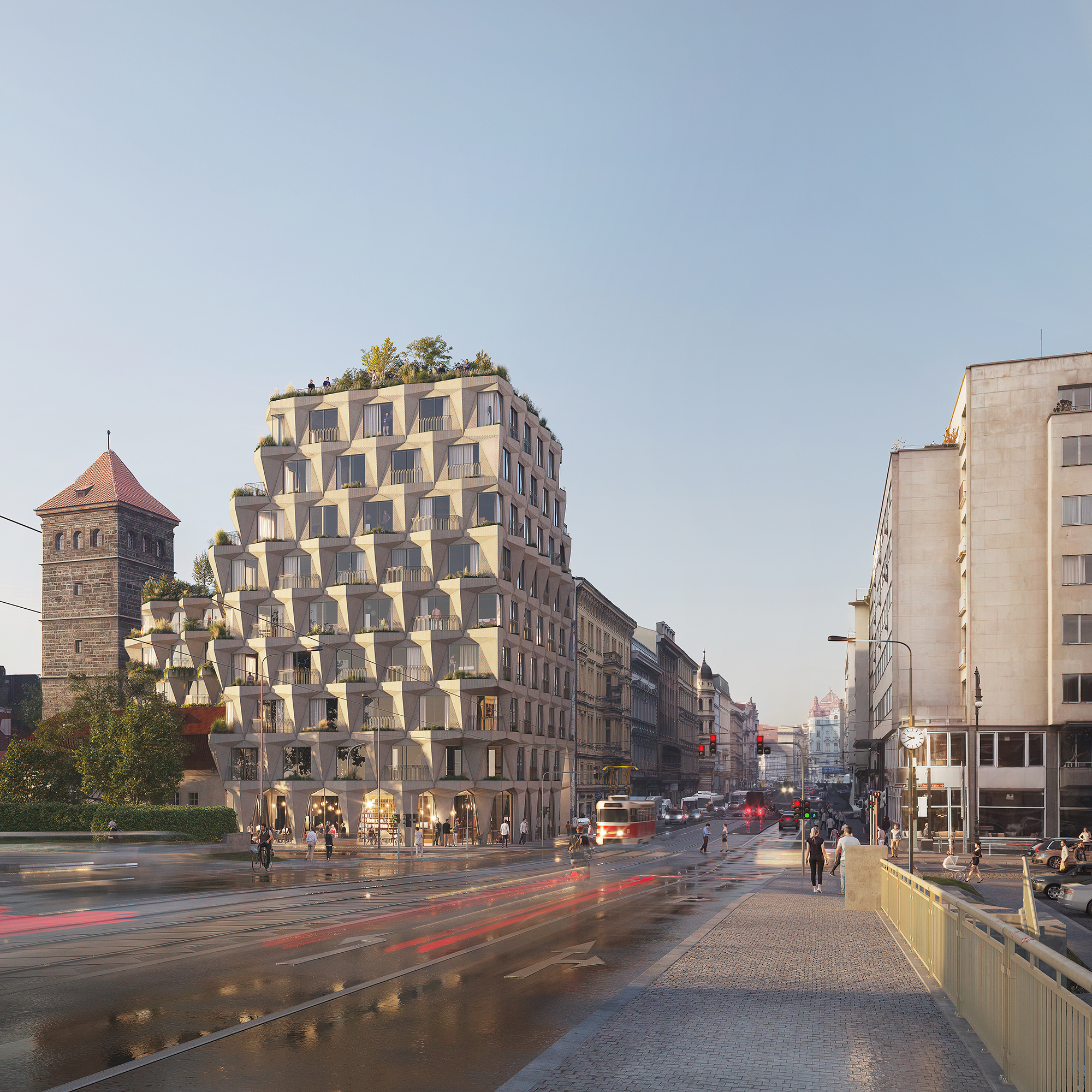

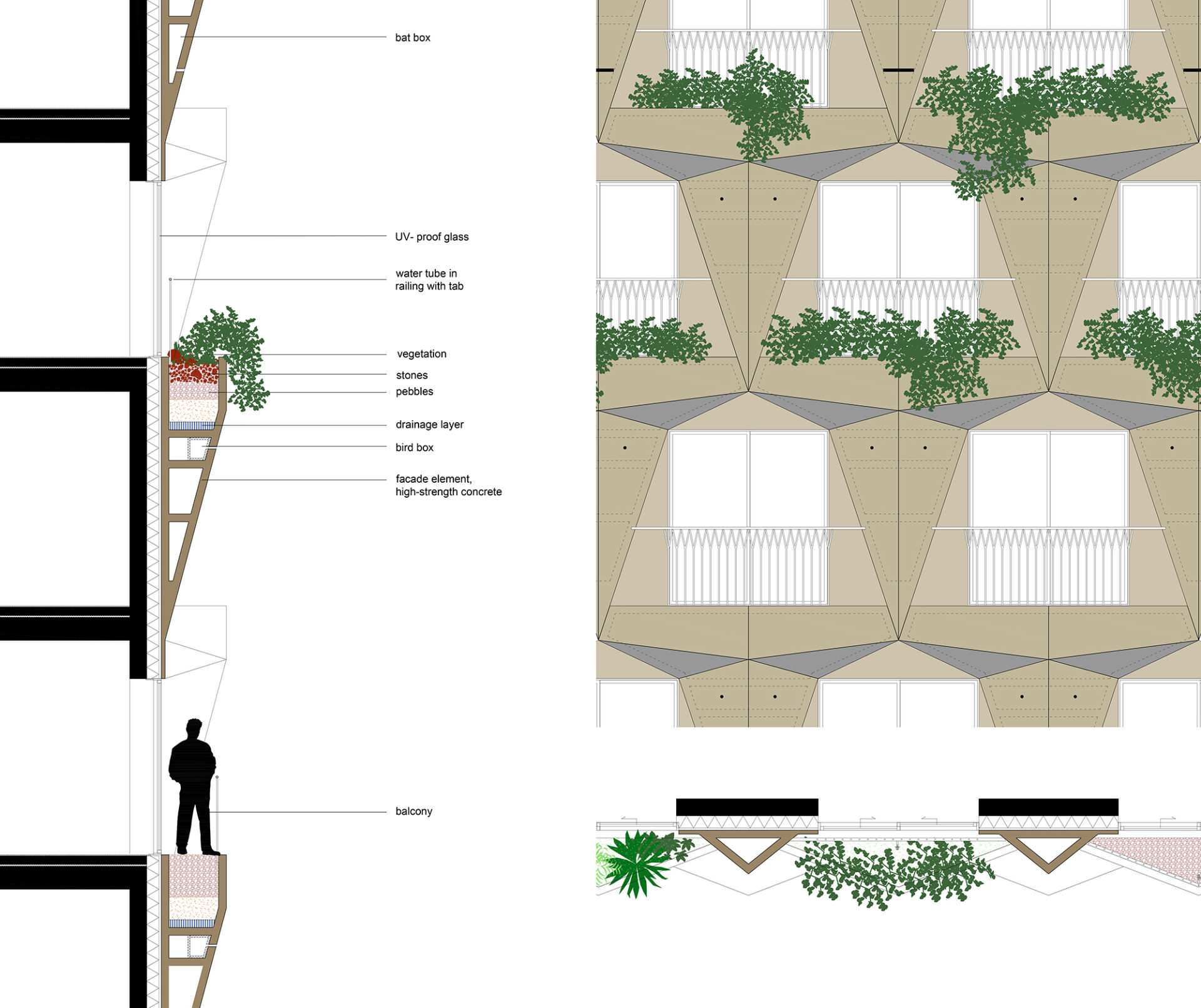
Green Revolucni

What type of icon do we imagine on this uniquely prominent site with its extraordinarily ambitious brief?

We believe it should be a contextual icon.
A building that stands out without being out of place by combining boldness with sensitivity for its surrounding.
It should be an icon that elevates the historic ensemble it is part of.
Rather than an abstract, introvert and self-referential object, it can be a layered and differentiated volume that creates a dialogue with the buildings around.


We believe it should be a paradigmatic icon.
An icon that embodies a paradigm shift: a shift towards a new future for the city.
A future in which cities are conceived as urban biotopes for people, plants, and animals.
Urban biotopes with nature inclusive architecture that boost quality of life ánd deal with the big global problems connected to climate change and loss of biodiversity.


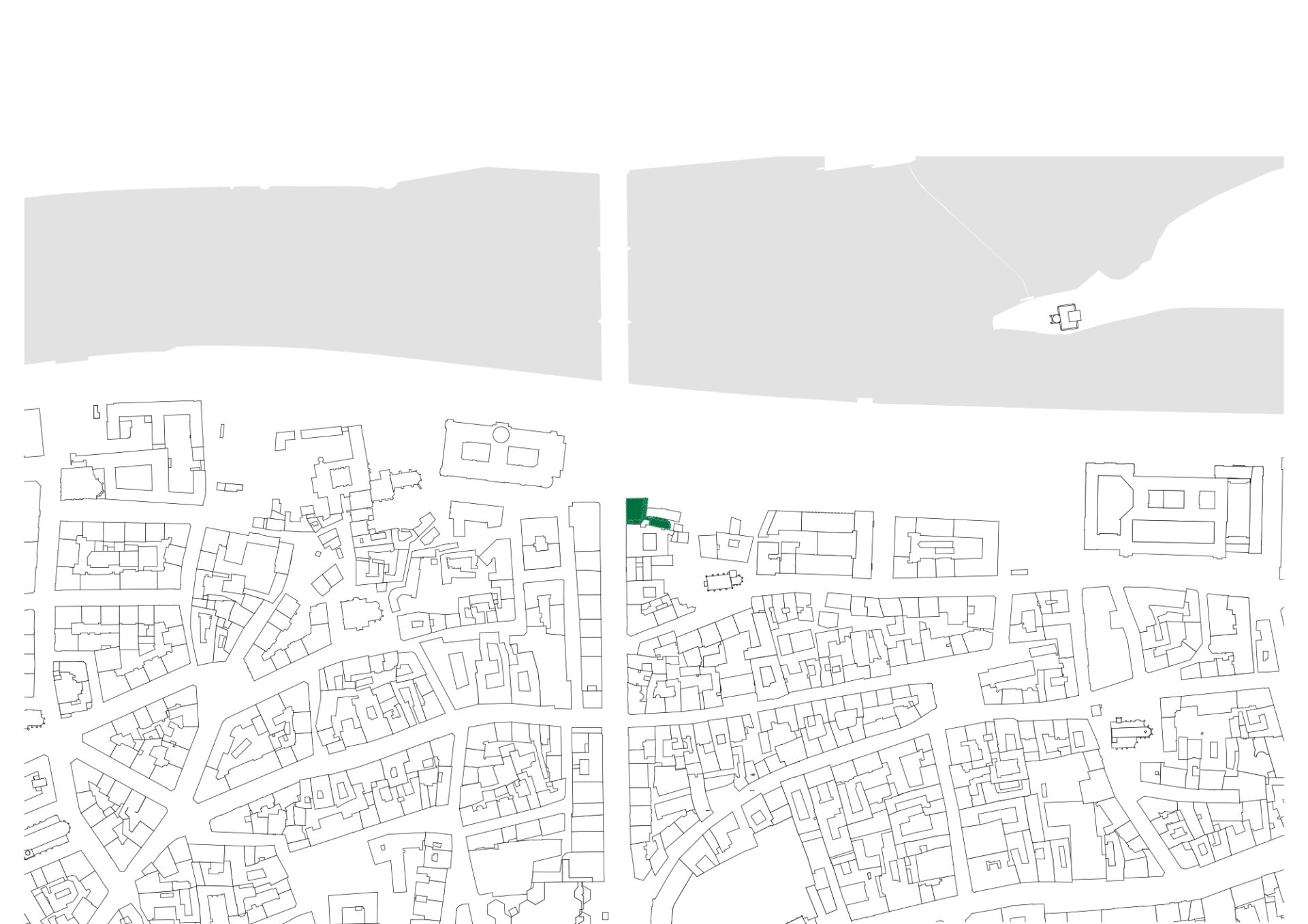
plans


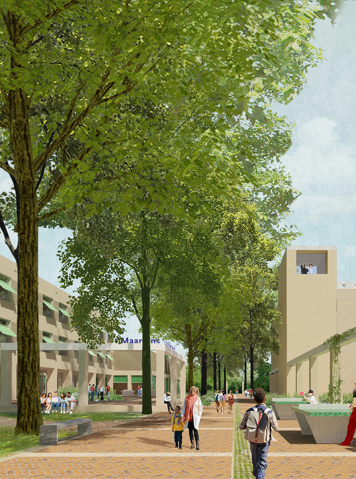
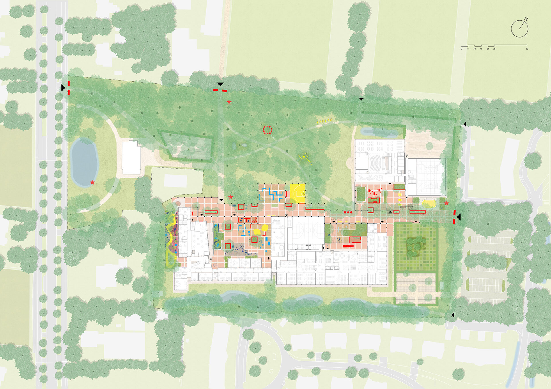
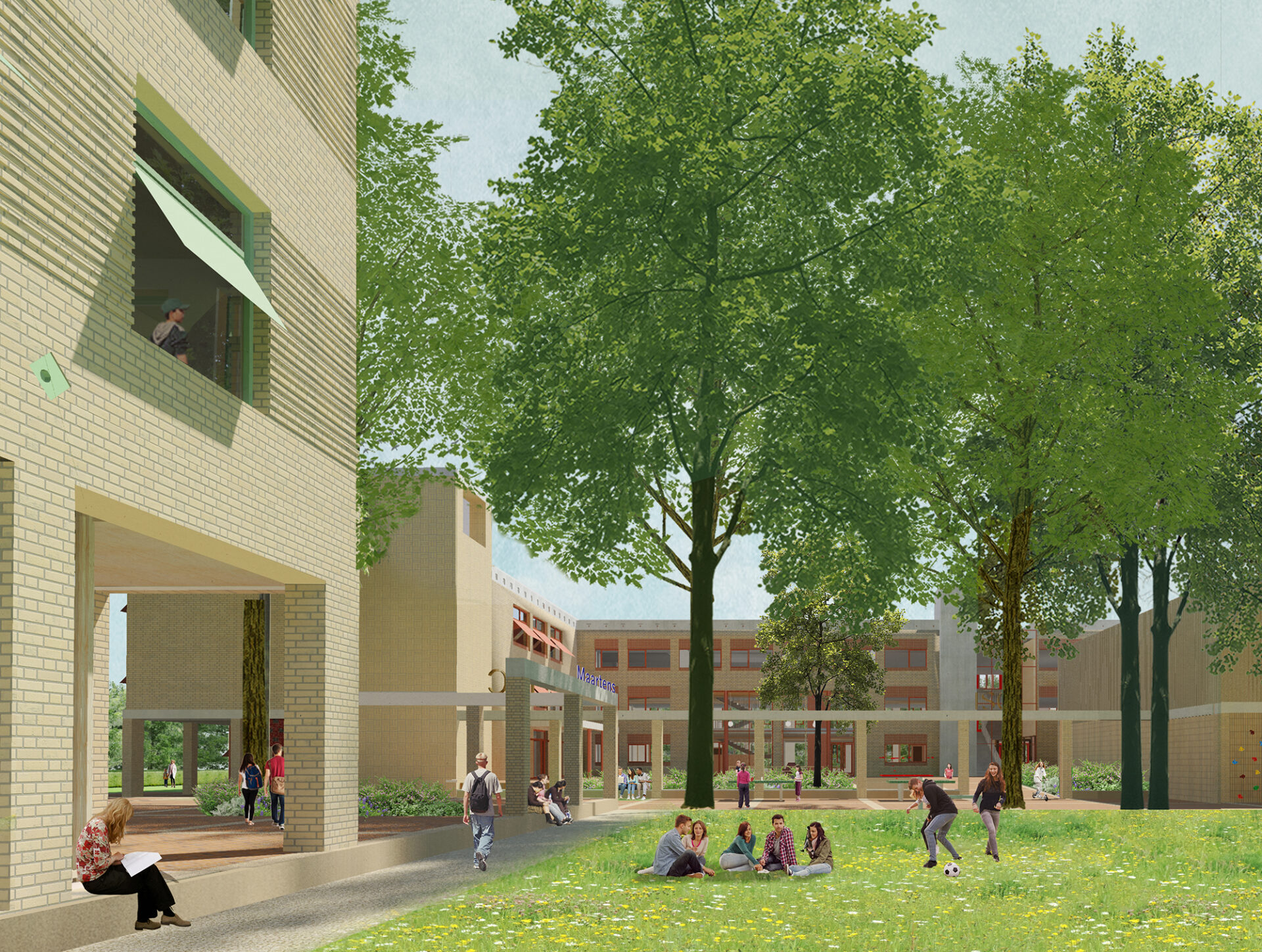
Campus Esserberg
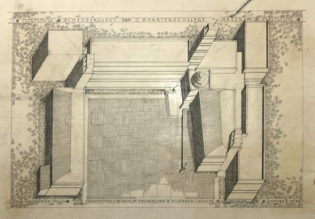
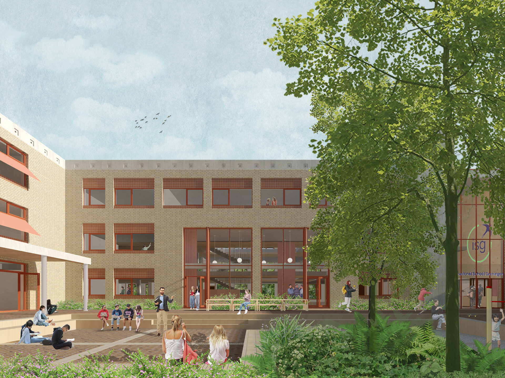
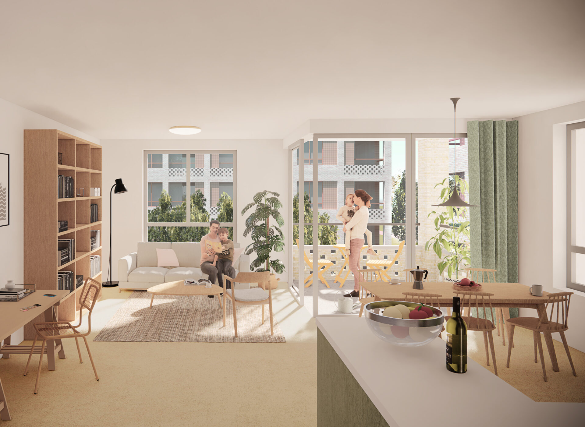
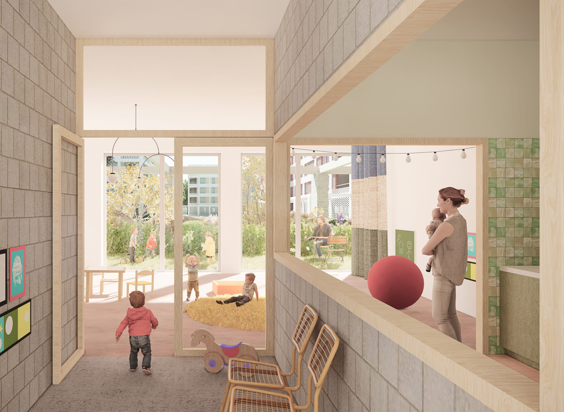
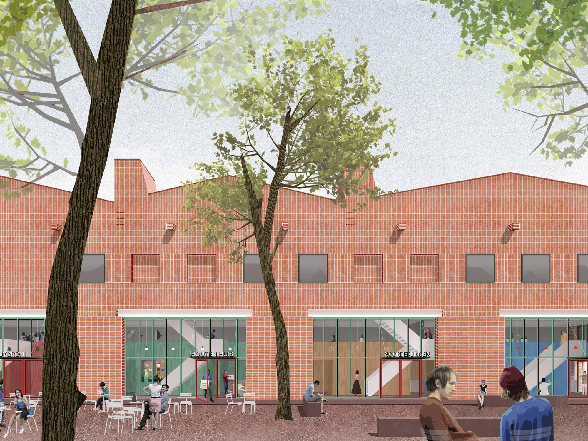
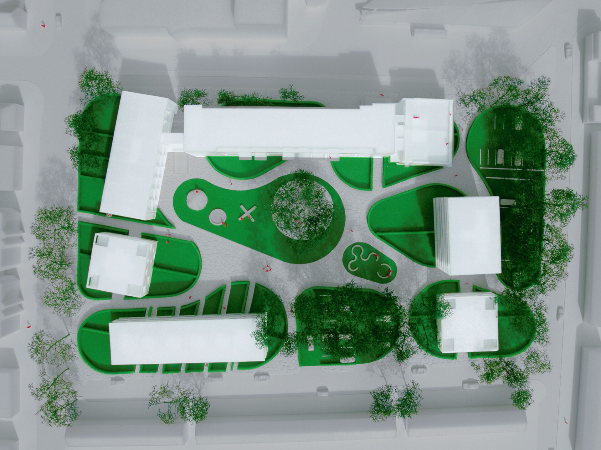
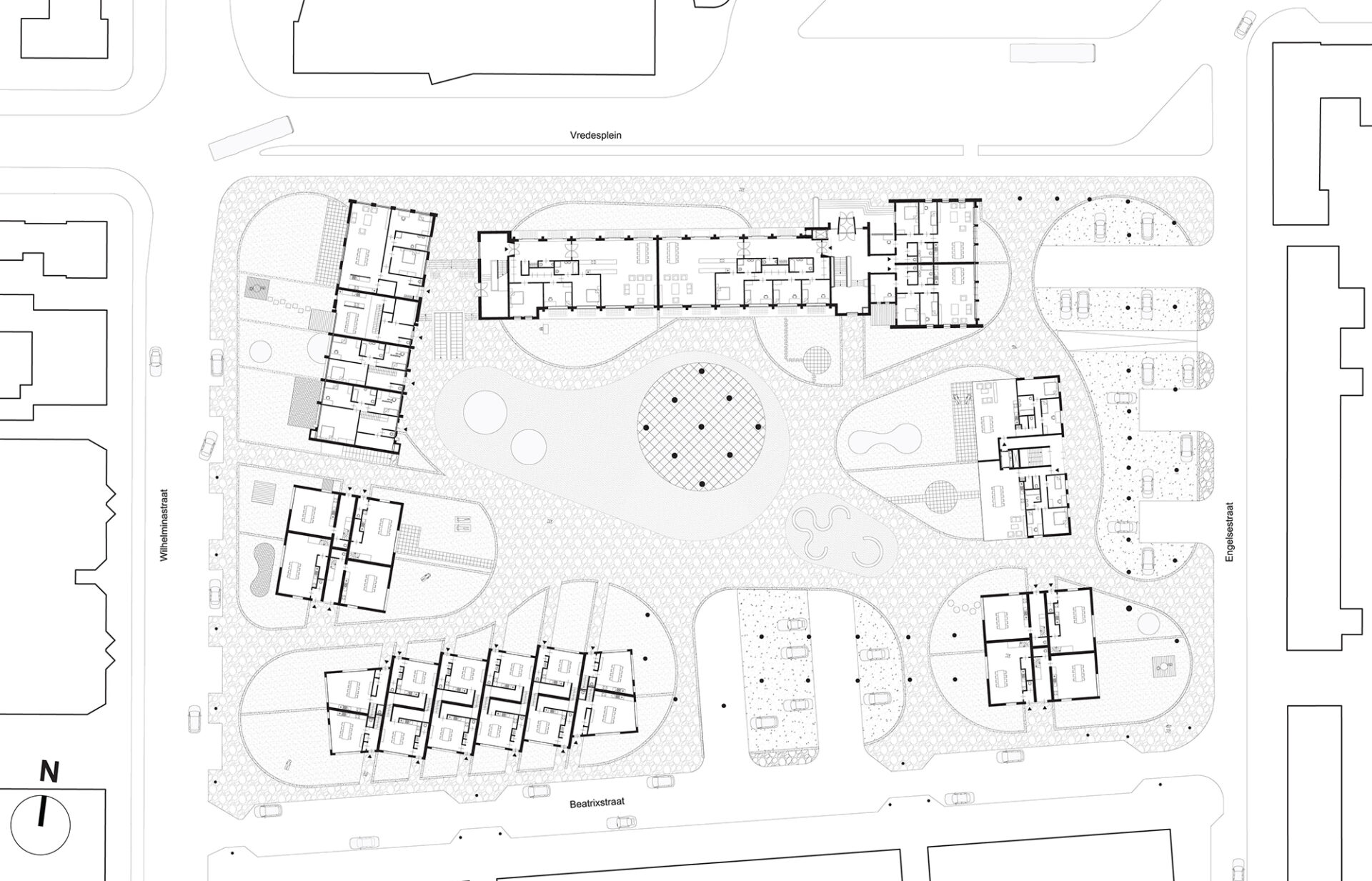
Located on the Esserberg estate between Groningen and Haren, the new campus will offer international and bilingual education for children and youth aged 0 to 18 years. The exceptional green location and the Bossche School architecture of the existing West Wing provide a rich cultural and historical foundation on which we are “building on” to realize a generous, cherished, and future-proof school environment.
More than in the current situation, the new campus will facilitate cross-pollination, knowledge exchange, and community building. However, in large school communities—and especially in international campuses—it is also important that students experience their own world so that they do not feel lost due to the size and complexity. We recognize this duality and aim for a school environment that offers both dynamism and openness on one hand, and tranquility and security on the other.
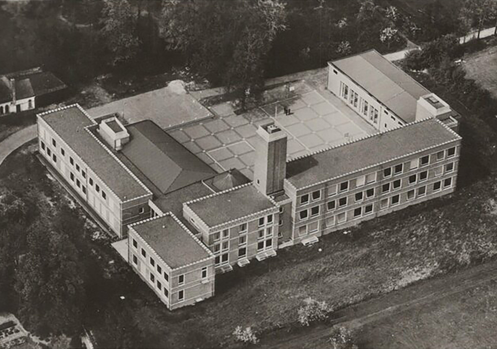
In designing both the buildings and the outdoor spaces they define, we are inspired by the philosophy of the Bossche School. This design philosophy provides harmonious unity through the use of a limited range of architectural elements. It is used to shape both the larger whole and the human scale. As a result, a coherent ensemble of legible buildings and outdoor spaces emerges, with a clear structure and recognizable domains that connect with the child’s experience of the world.


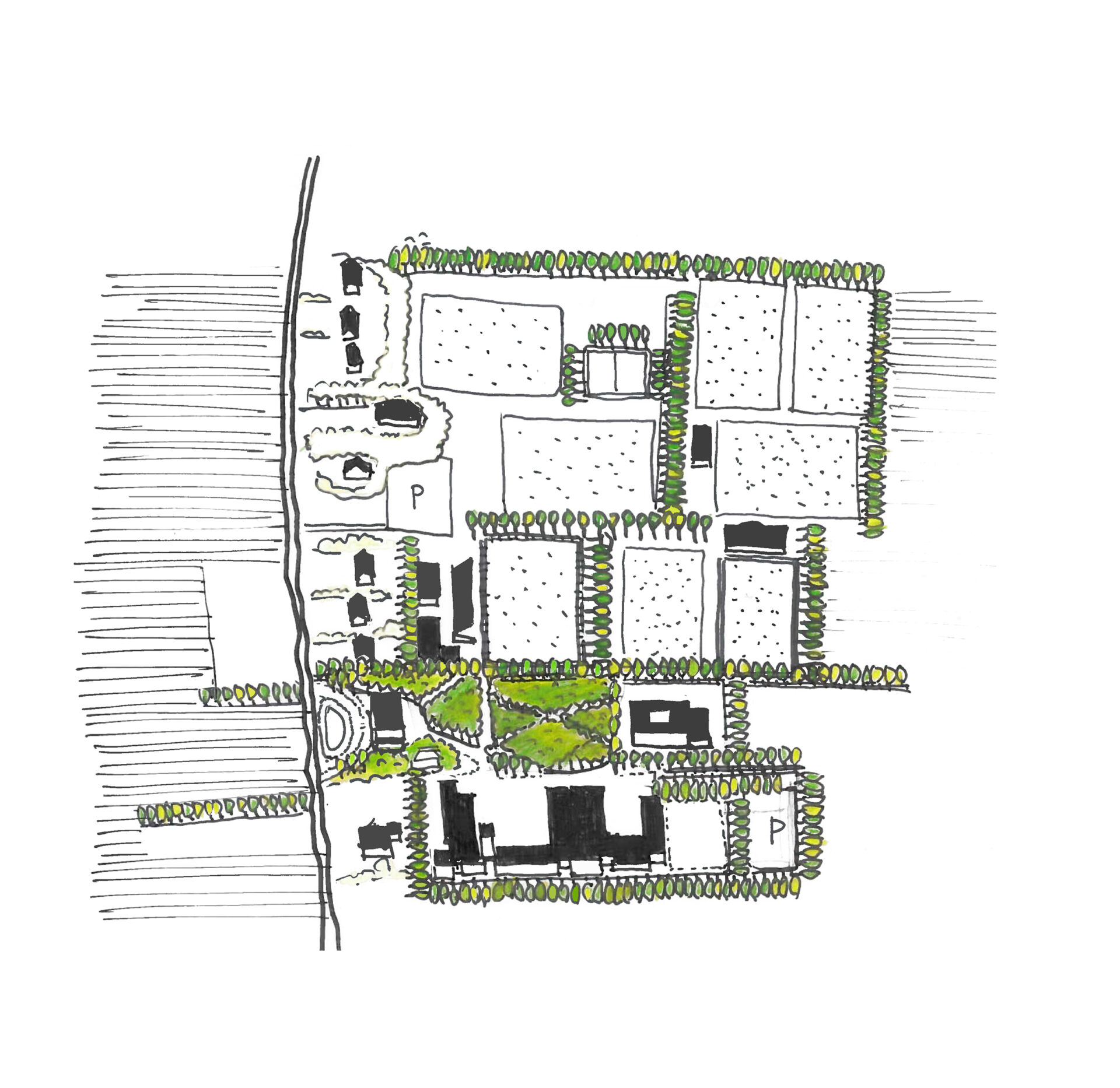
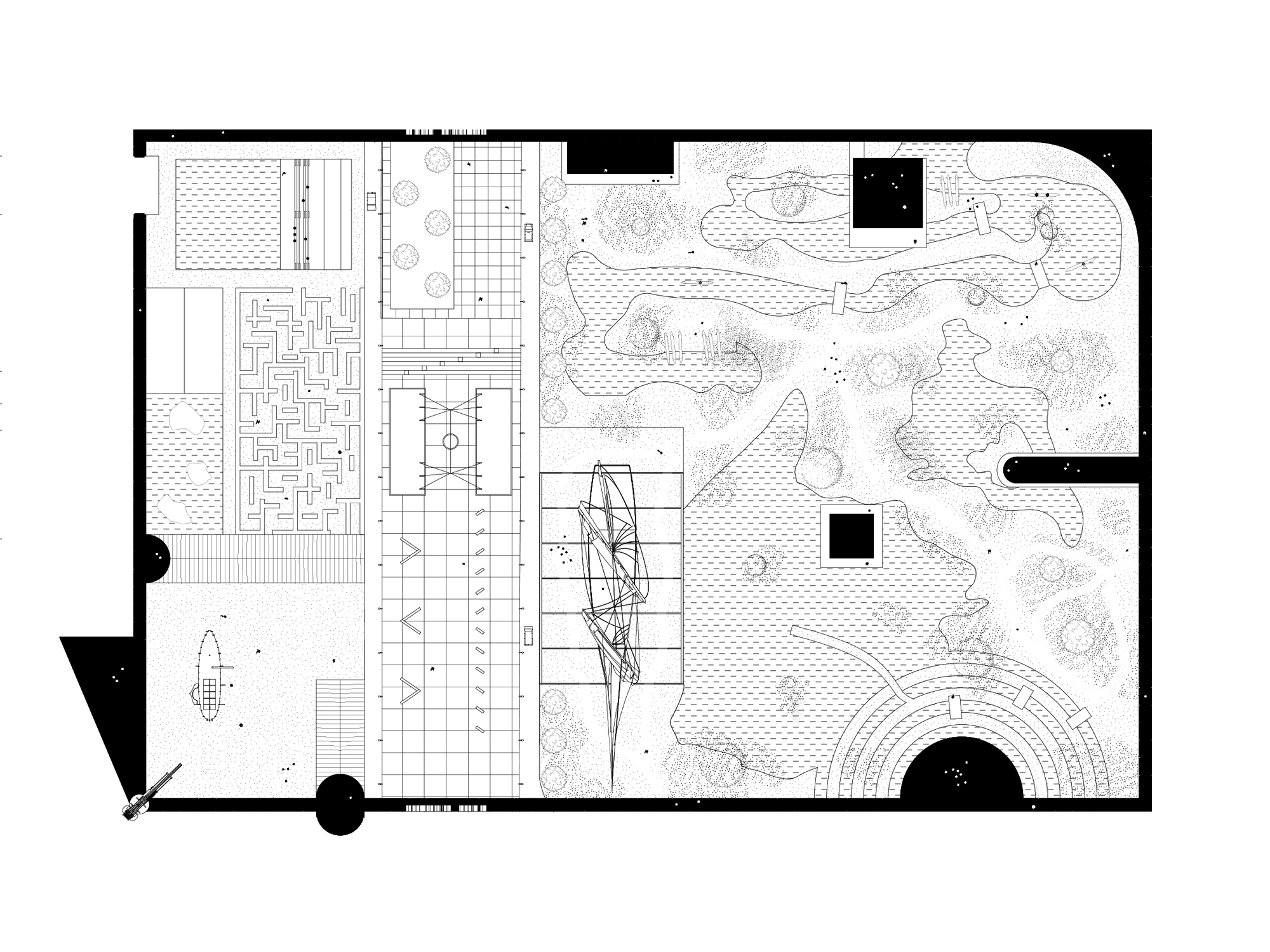
The historical framework of green rooms defined by tree-lined hedgerows forms the landscape backbone of the plan. It provides the campus with a sense of enclosure and serves as the unifying element that weaves the diverse programs into a single whole. The cultural-historical and landscape typology of the estate gives the campus its spatial identity. New buildings and outdoor spaces are carefully integrated as autonomous components in a cohesive architectural composition. This creates a clear structure that offers space and hierarchy for a patchwork of places designed for different target groups and age ranges. Most of the outdoor program is concentrated along the Landgoedlaan. This allows the wooded park to remain forest, unnecessary pathways to be returned to nature, and the ecological value of the estate to be enhanced.
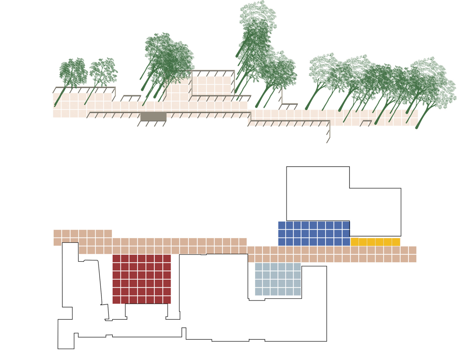
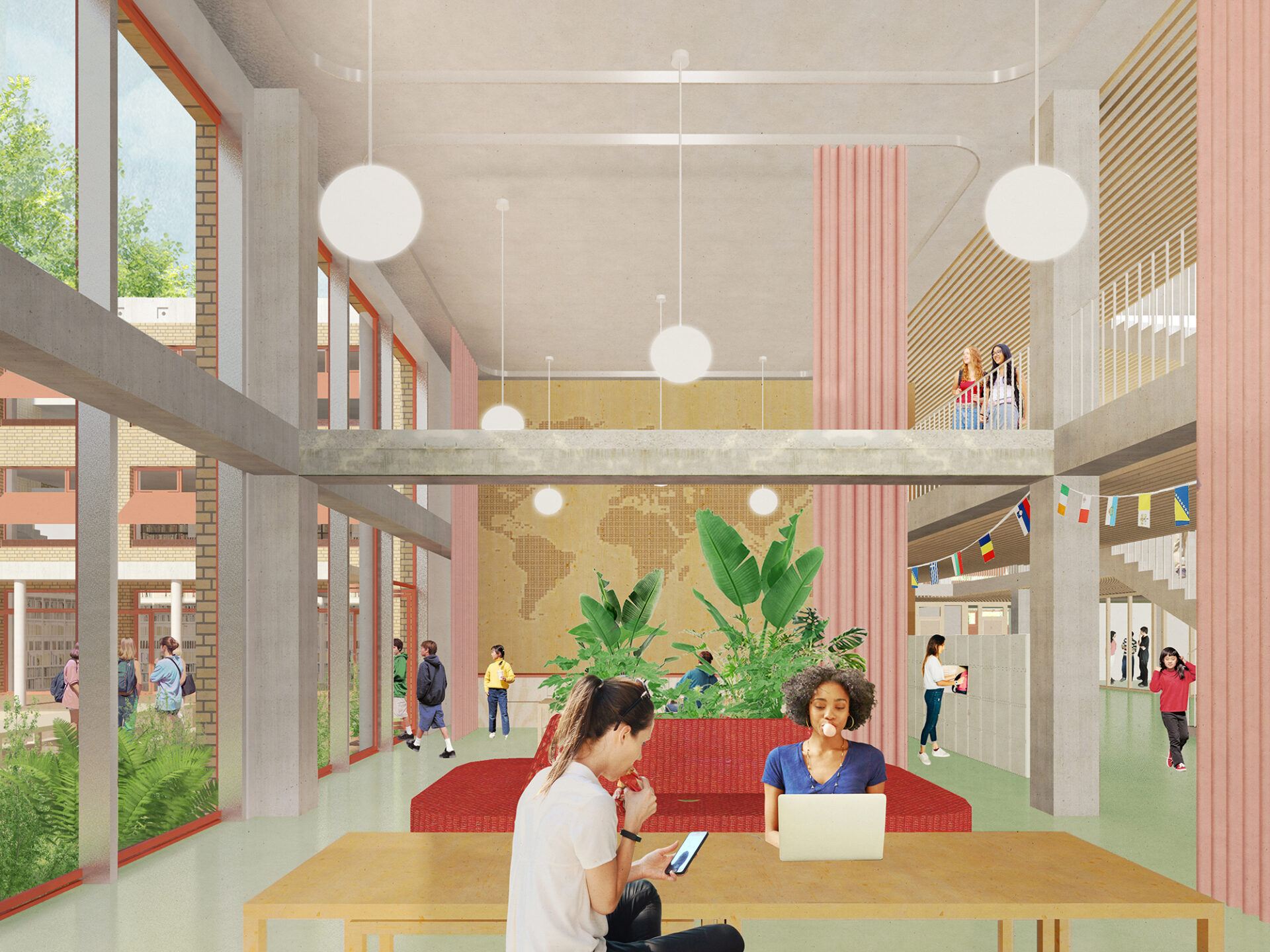
The Landgoedlaan forms the central spatial connector of the campus. It links all facilities and gives them an address on the campus. In addition to its role as a circulation route, the Landgoedlaan provides space for encounters and interaction among different users. It acts as a xenophile space: a space for the “friendly stranger,” where hospitality, respect, and community-building are central.
The space is lined with existing monumental trees and a new pergola structure, inspired by the architecture of the Bossche School. This pergola forms a frame that defines the space from the surrounding nature, creating a sense of enclosure. The pergola not only provides the Landgoedlaan with a recognizable identity but also marks the transition between the public domain of the lane and the private schoolyards.

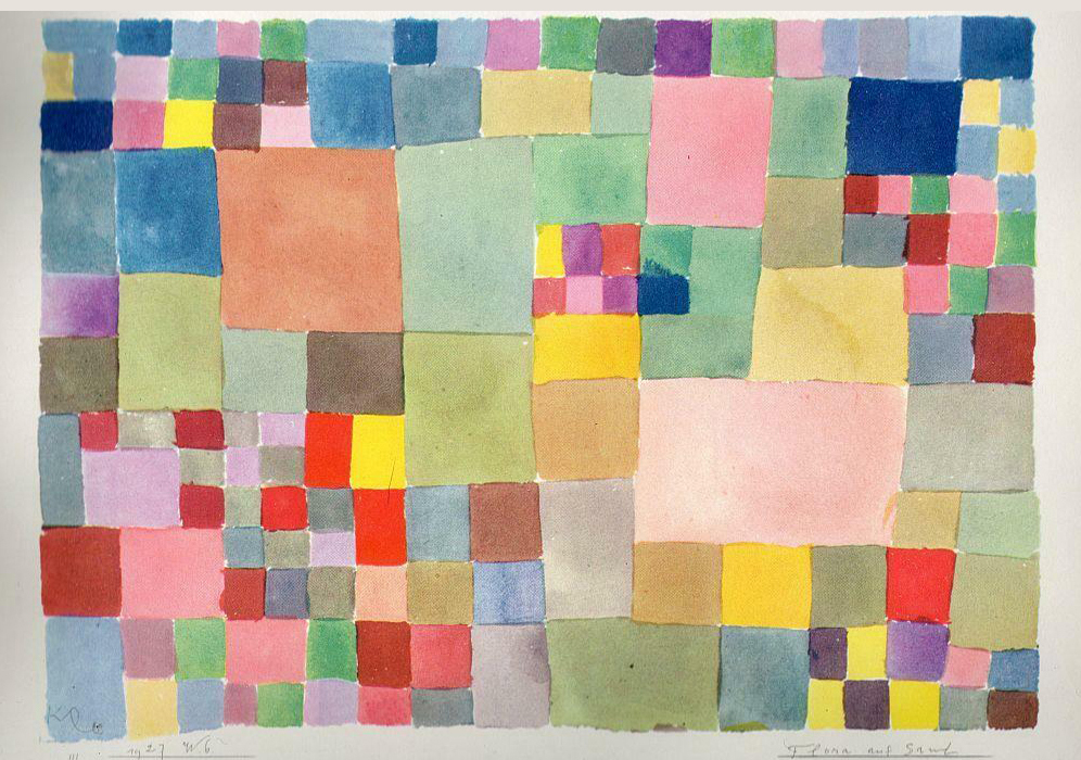
The original 5x5m grid in the paving of the West Wing is extended into the Landgoedlaan to structure the entire ensemble of buildings and organize the various outdoor domains. It introduces a comprehensible scale that aligns with the child’s perspective and makes it possible to structure outdoor spaces for different age groups in a clear manner. At the same time, it offers unity and recognizability for the community. The grid is made from paving bricks and filled in with reused building materials from the East Wing. The 5x5m module allows for a wide range of potential programmatic uses that encourage learning, socializing, play, and movement. Based on a catalogue, we will work with users to determine the final “patchwork of places” for the lane and courtyards.
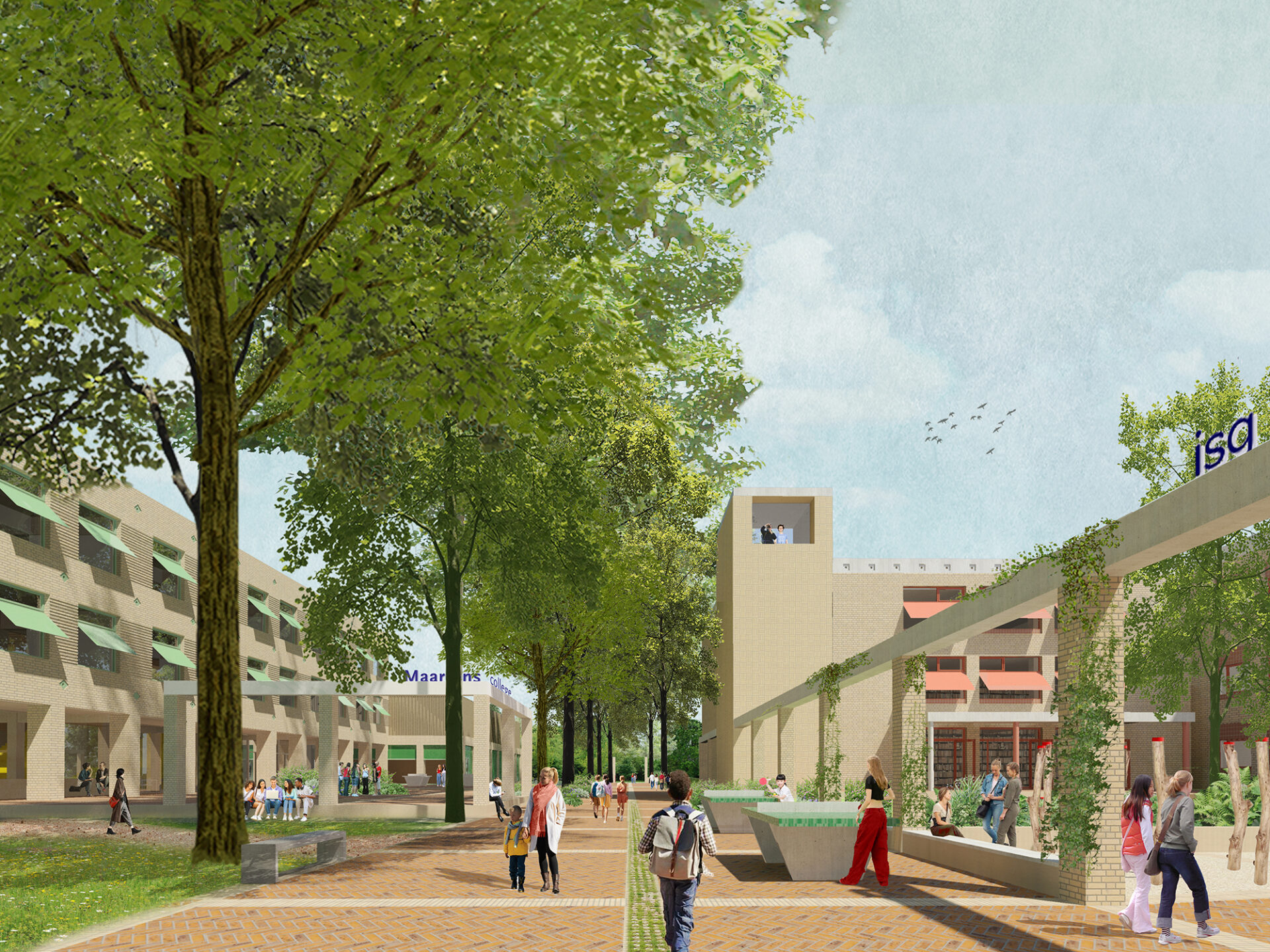
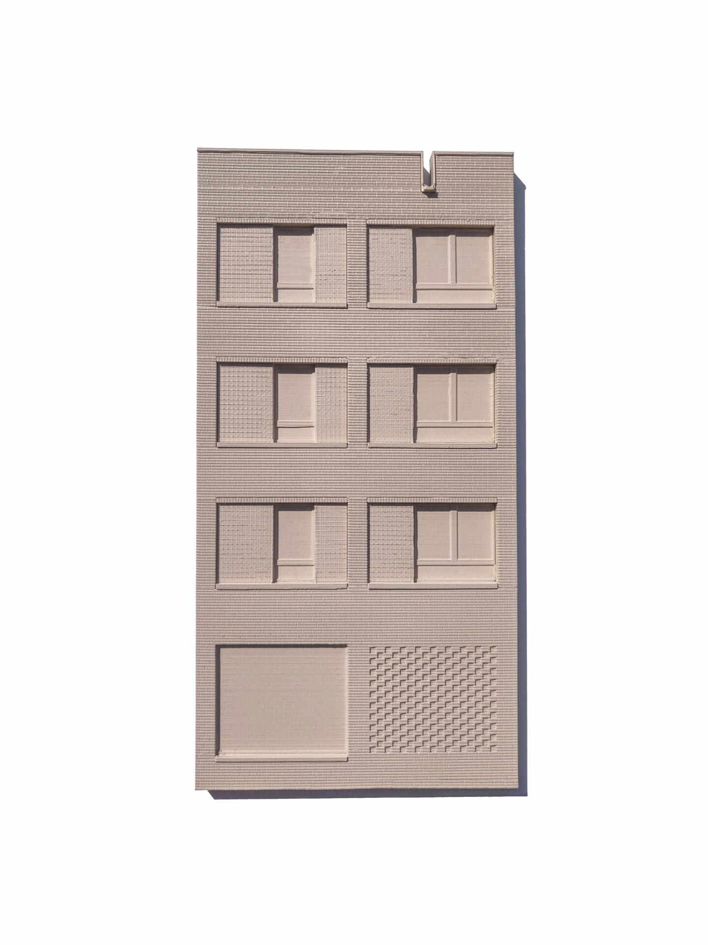
The new buildings, as well as the extensions, adopt the architectural DNA of the existing West Wing. This results in a family of buildings that belong together while each retaining its own character. Analogous to the West Wing, both extensions and new buildings are designed as composite volumes, in which the grain size and the yellow-brown ceramic bricks of the West Wing are recognizable. Through subtle differences in facade rhythm, relief, brickwork patterns, and ornamentation, each school gains its own identity. The different domains are further emphasized in the interior design, tailored to the experience of each specific age group.
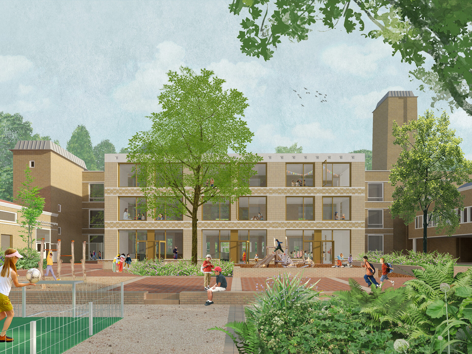
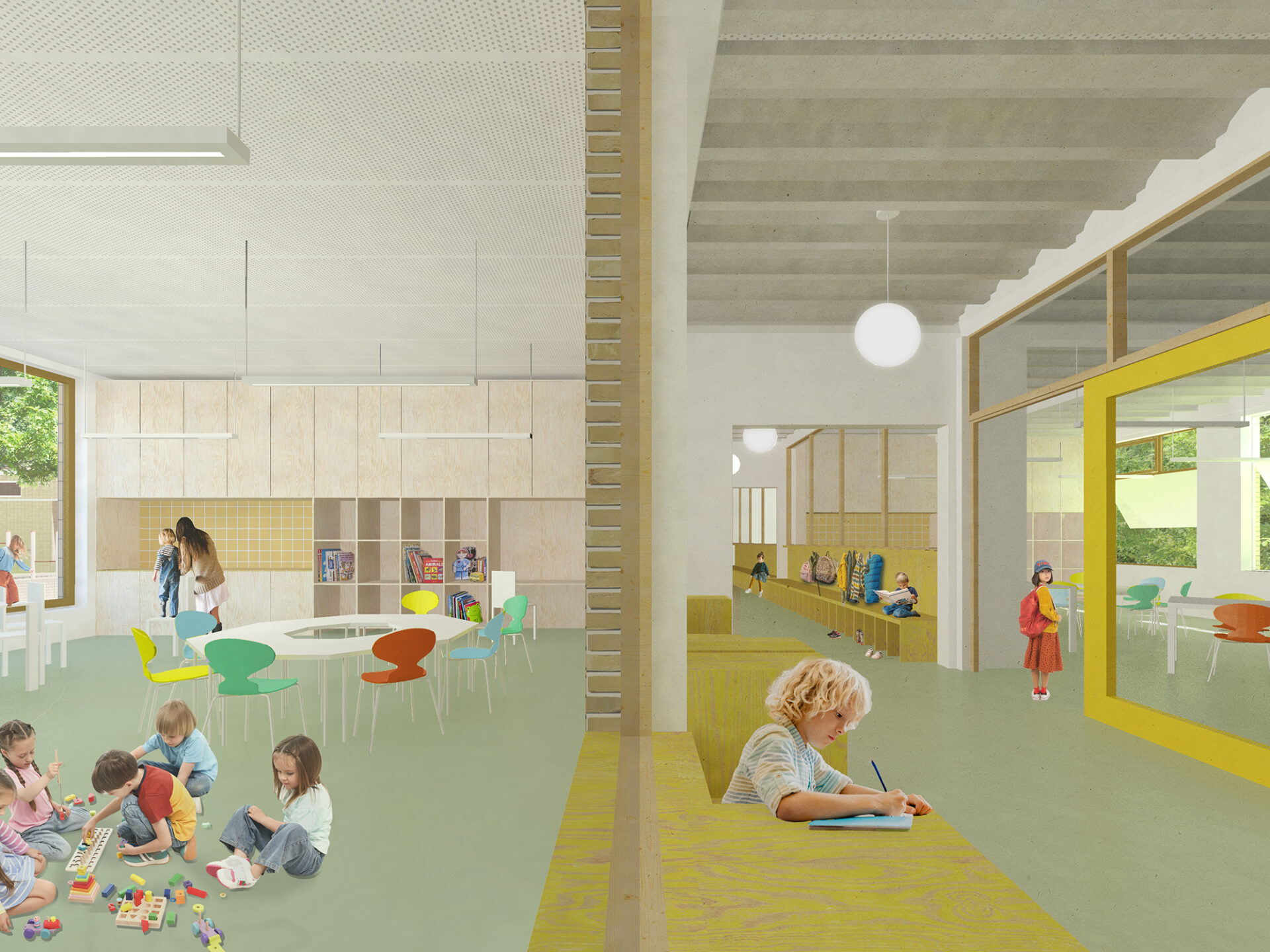
The school buildings are modular and flexible in layout (based on the standard module of a classroom), allowing them to adapt within a single structural framework to evolving educational insights and conditions. The modules can be combined to form larger spaces or subdivided further to accommodate smaller support functions. Along the Landgoedlaan, all major communal functions are organized to ensure they are visible and accessible to the campus community.

To keep new construction as compact as possible, as much of the program as possible is realized in and adjacent to the existing East and West Wings, effectively “retrofitting” them. In addition to energy efficiency and careful material selection, the design aims to create a high-quality and comfortable learning environment that is functional, cherished, and therefore future-proof.
We primarily strive for low-tech buildings that, through smart design and material choices, intrinsically support a pleasant indoor climate. The layout of the shell—with a demountable column-beam structure and a strategically chosen grid—makes it possible to reconfigure the floor plans in the future. Finally, we aim to create beloved buildings that are durable and aesthetically layered—buildings people feel connected to and take care of.
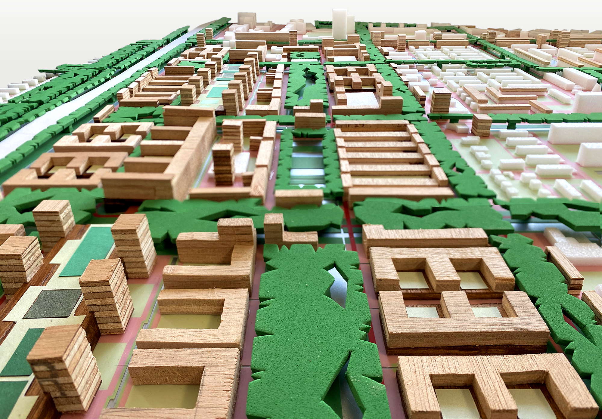

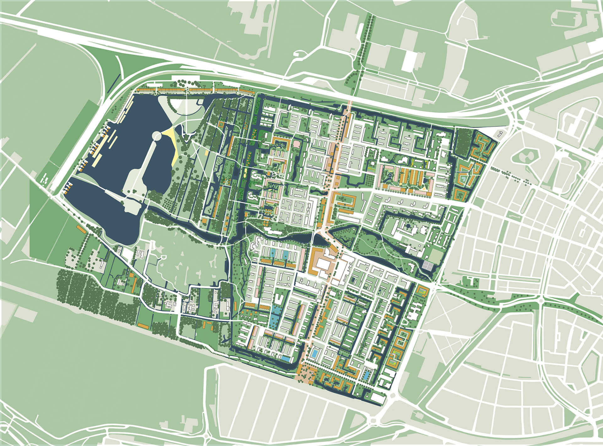
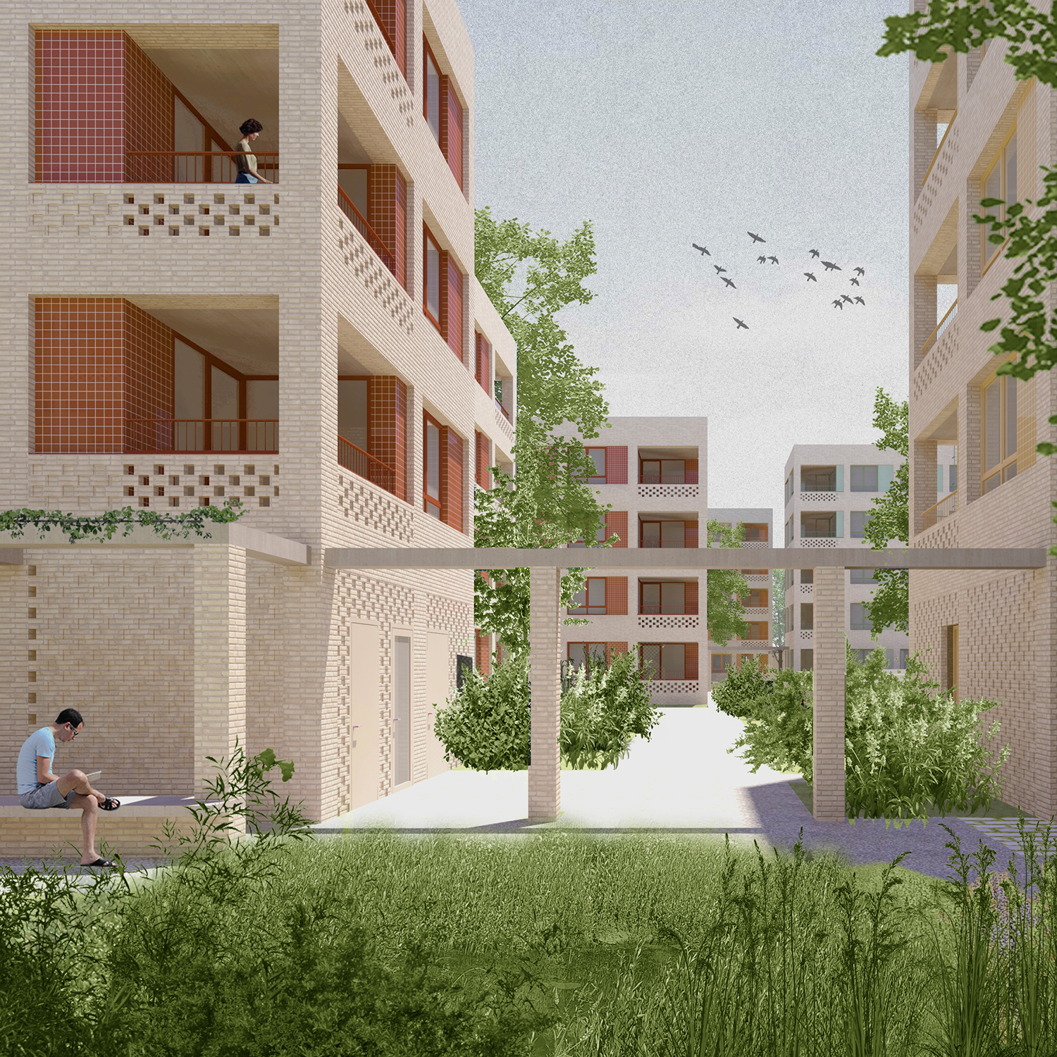
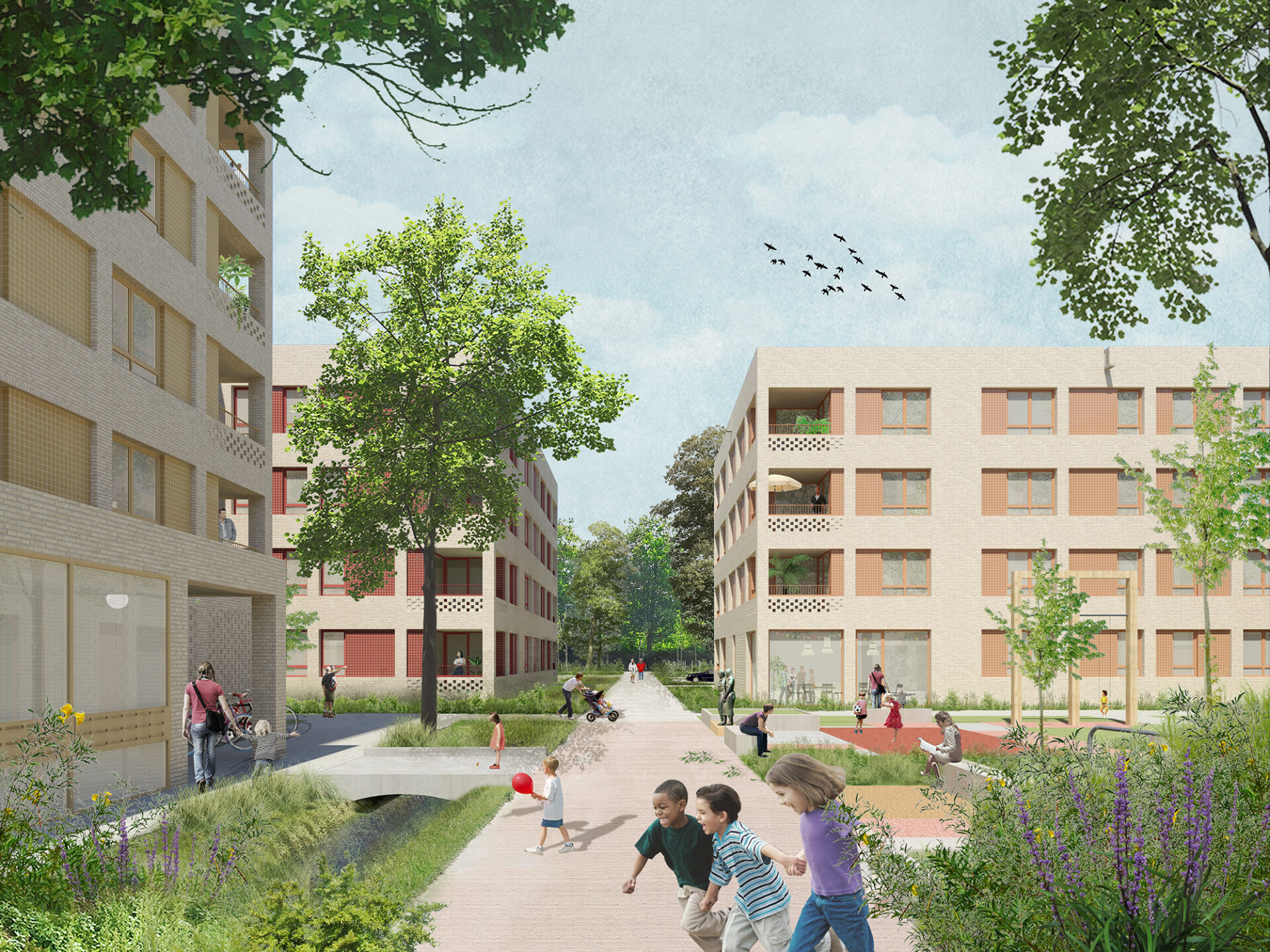
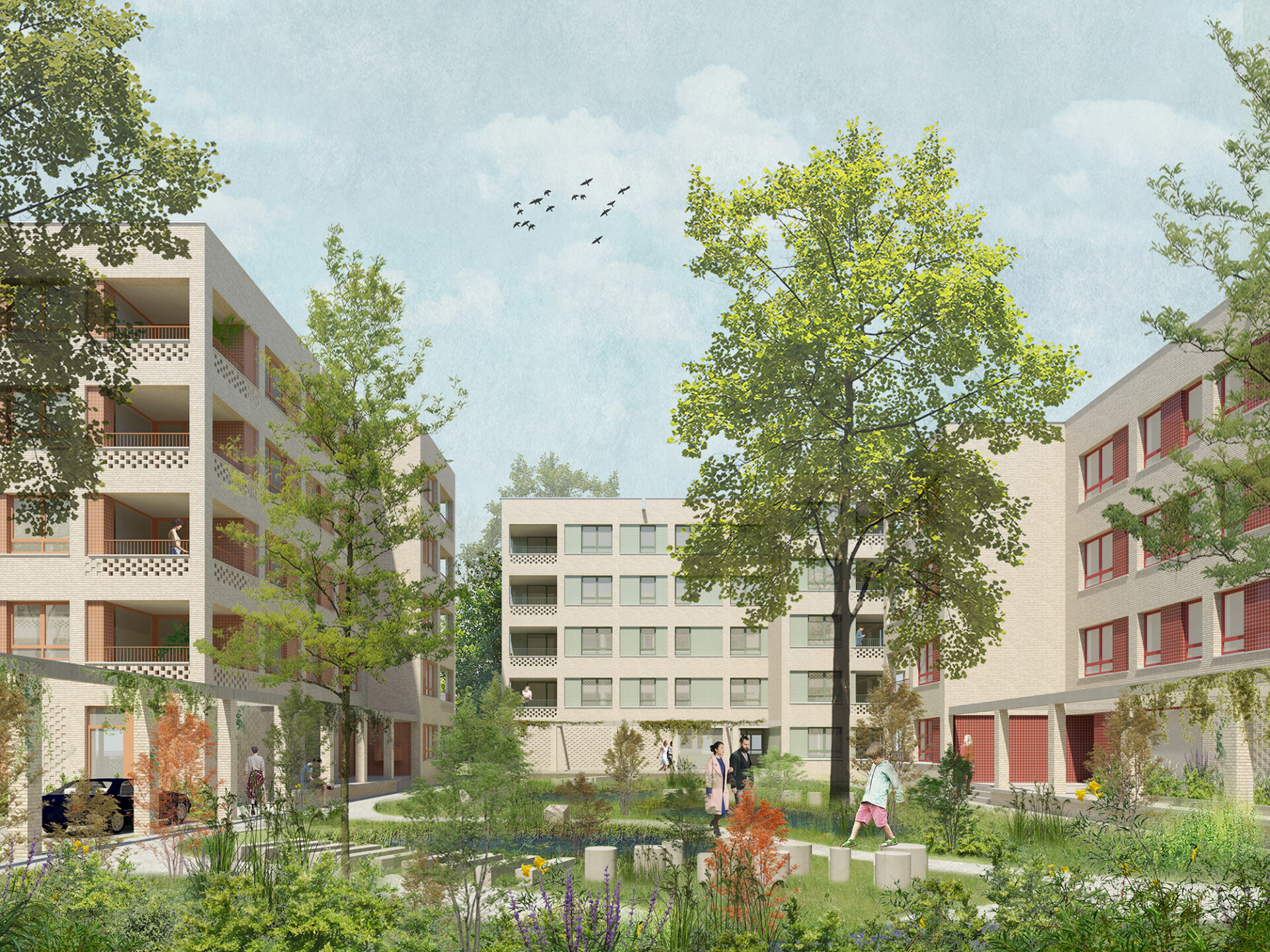
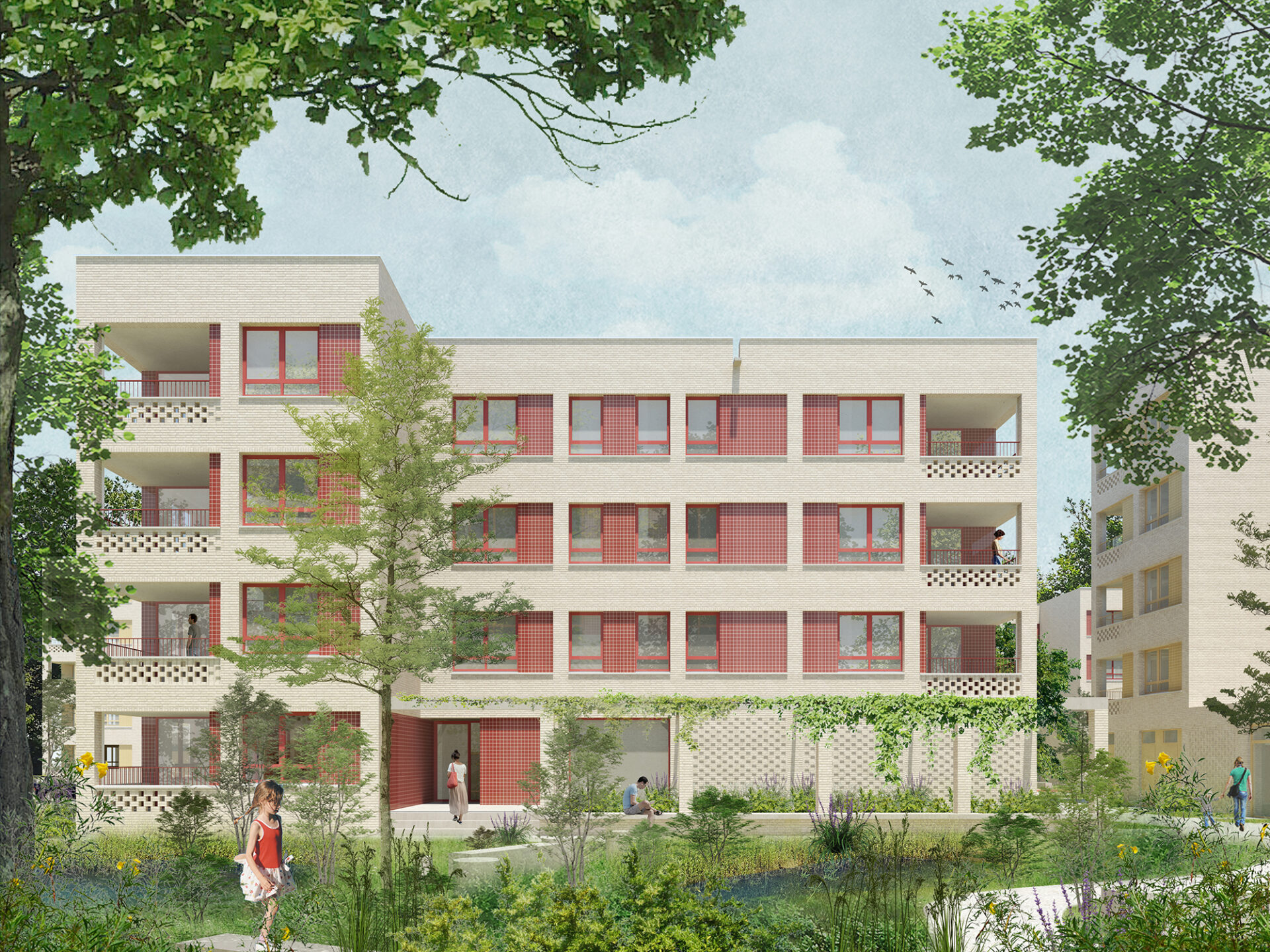
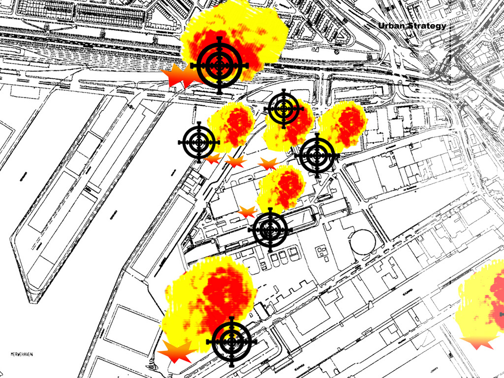
The new existing city
is the title of our entry for the Ministerie van Maak exhibition, following the call to 100 designers to come up with concrete solutions for the housing shortage, the energy transition and the consequences of climate change. Our plan shows how the Rotterdam post-war district Het Lage Land can be densified with 15,000 new homes, new working places and various amenities. The 100 models are showcased during the 2022 Rotterdam Architecture Biennale, in the largest scale model ever made of the Netherlands.
We believe that a significant part of the housing to be built in the coming years must find a place in the existing city. After all, that is where all the facilities, the infrastructure and especially the public transport nodes are located. Inner city densification can also serve as an opportunity to address the water, climate and energy assignments in the existing neighborhoods. And it can provide the necessary new housing typologies for existing residents, elderly for instance, so that they don’t have to leave the neighborhood.


Rotterdam “urbanized landscape”: an agglomeration of introvert islands within the system of the traffic machine
(after a drawing by Frits Palmboom)
Our location, the post-war modernist district Het Lage Land in Rotterdam, is fertile ground for further densification. Not only with homes, but also with spaces for work, water and greenery. The modernist idiom of separation of functions has resulted here in spacious, introverted residential islands surrounded by oversized transition areas, residual spaces and infrastructure. There is a need for a new urban layer that densifies, differentiates and connects this district with the city around it.


the postwar district Het Lage Land is in need of a new urban layer
The plan makes use of Oswald Mathias Ungers’ concept of Grossformen (megaforms), that unite flexibility and adaptability with permanence and a strong architectural expression. By framing the existing district with a metropolitan fabric consisting of city streets and work-live city blocks, the plan injects urbanity, form and connections in the peripheral residual buffer zones, characteristic of most modernist districts.


We transform the Prins Alexanderlaan, a 100-metre-wide thoroughfare east of the district, into a metropolitan city street. The metro line, located on the ground level, is flanked and topped with facilities and dwellings. The space for the car is limited in favor of cyclists and pedestrians. This gives the adjacent district Lage Land a representative front in the form of sturdy city blocks with dwellings, facilities, shops and offices that focus on the new city street.


We transform the Prins Alexander industrial premises and the adjacent communal- gardens location into a new mixed live-work district. The current low occupancy and low employment rate on this prime location situated right next to the Rotterdam Alexander train station, makes it ideal to partly preserve and partly intensify the existing businesses with new ones and combine them with up to 10,000 new homes. The railway line, located on a dike, will be provided with underpasses and an overpass, dissolving its barrier effect. The parking program of the entire district will be situated above the railway line. The business/industry areas are located under and inside the building blocks. They are accessed from a circular loop, which means that the entire development itself can be car-free.


We transform the neighborhood itself with acupunctural infills and a green-blue network that enhances the biodiversity and the sponge effect of the district. New slow traffic paths connect the neighborhood with its surroundings, including the Kralingse Bos, which we are expanding with a sports forest up to the highway. The Prinsenlaan will be transformed into a linear park connecting the Kralingse Bos with the Schollebos.


acupuncture in the existing district


Large-scale densification, as we advocate it, is complex. Too complex to be left solely to the market. The management should lie with the municipality. The design disciplines also need to sit more firmly at the table. After all, it is the architects par excellence who can think integrally and literally give shape to THE NEW EXISTING CITY.


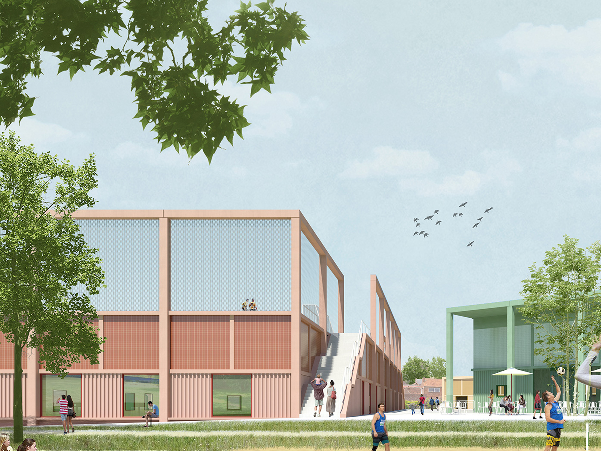


SportHalle on the Zenne
Sport – once the exclusive domain of sports clubs – is now an inseparable part of everyday social life. Sport charges public space with activity, dynamism and social encounters. The social and economic value of sport is at the forefront of politics, the civil service and the media. The importance of sport in society gets its spatial translation in Halle through a new urban typology: the hybrid urban sport park, which is embedded both spatially and programmatically in the existing city. The sports cluster is not a building or complex but, above all, an important public place within Halle’s inner-city pedestrian network.


The new sports building manifests itself at ground level as a cluster of three volumes around a sunken patio. The modest footprint and height of the volumes above ground preserve views and leave room for two pedestrian connections from the surrounding residential buildings towards the Zenne park.

The volumes represent the aboveground part of the main sports hall and the gym as well as a centrally located park pavilion where the reception, the cafeteria, the offices and the meeting room are located. The transparent park pavilion forms the link between indoor (sports) and outdoor (sports), between park and patio and between the upper world and underground sports world organized on two levels.


plans of ground level and -2 level
The -1 level is for the spectator, in the form of a balcony with views on all sport halls. The sunken patio located here forms the heart of the sports cluster, providing daylight and orientation to the visitor. The -2 level is the domain of the athlete, giving access to the multi-purpose hall, the main hall, the martial arts hall and the gymnastics hall. The two main halls are provided with generous windows on all sides at ground level and open completely on one longitudinal side towards the balcony on level -1.


The main hall is dimensioned (67x32m) to increase flexibility and permit a wider range of sporting opportunities. The multifunctional pavilion and the clear logistics with separated levels for athlete and spectator/visitor ensure that the sport cluster can also accommodate other functions such as markets, parties, performances, exhibitions or major school exams.
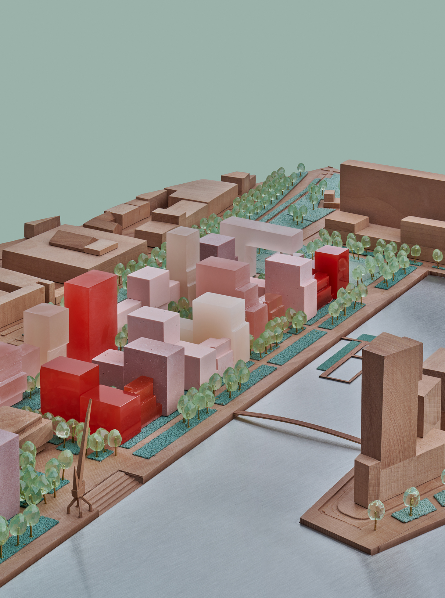

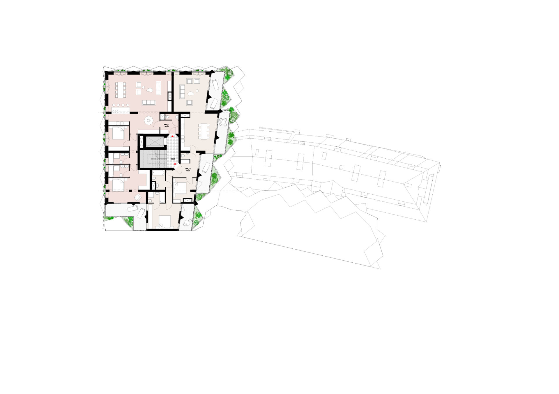
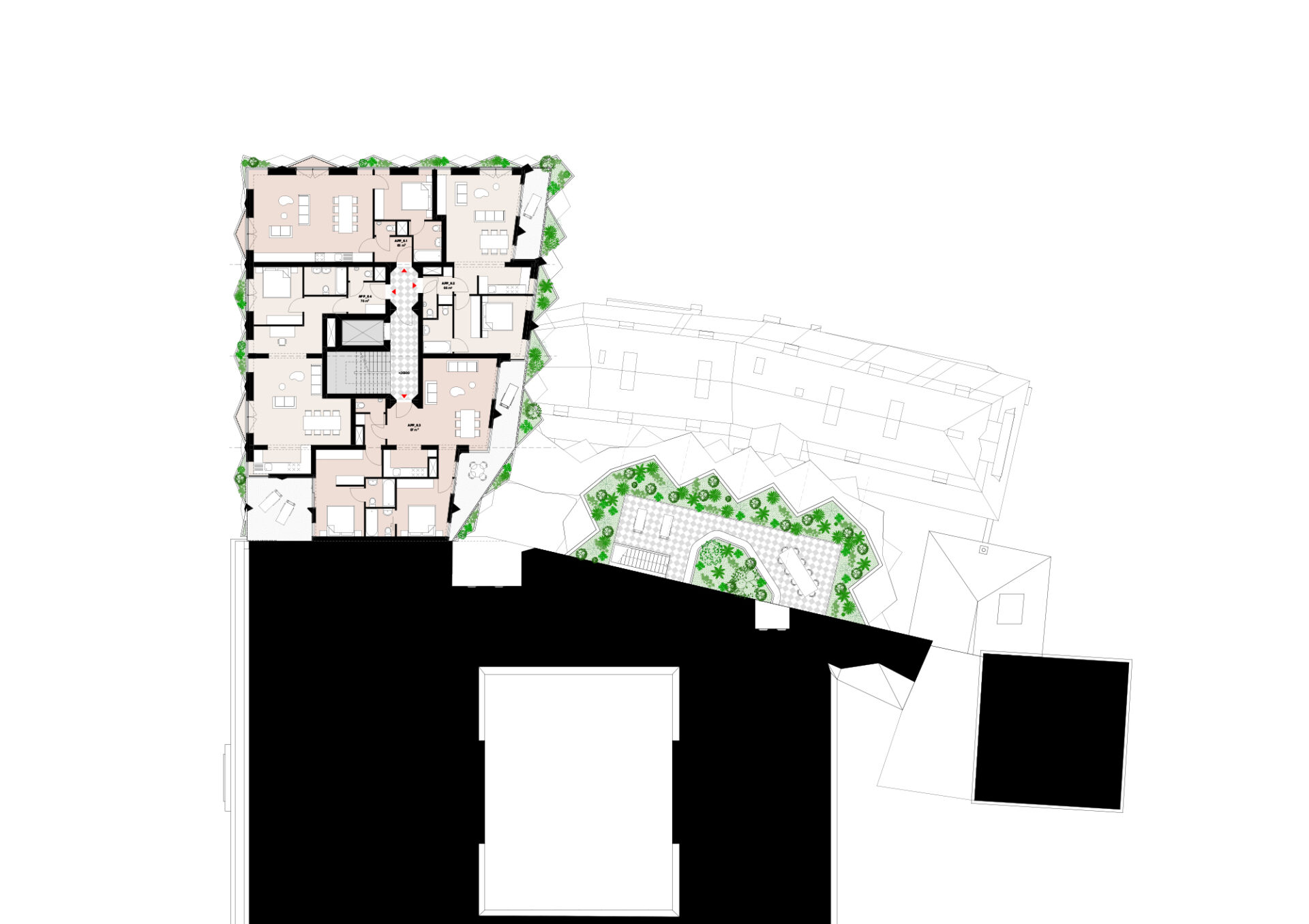
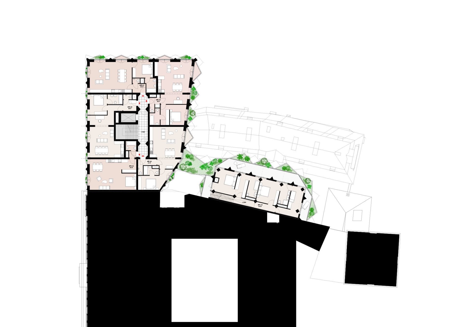
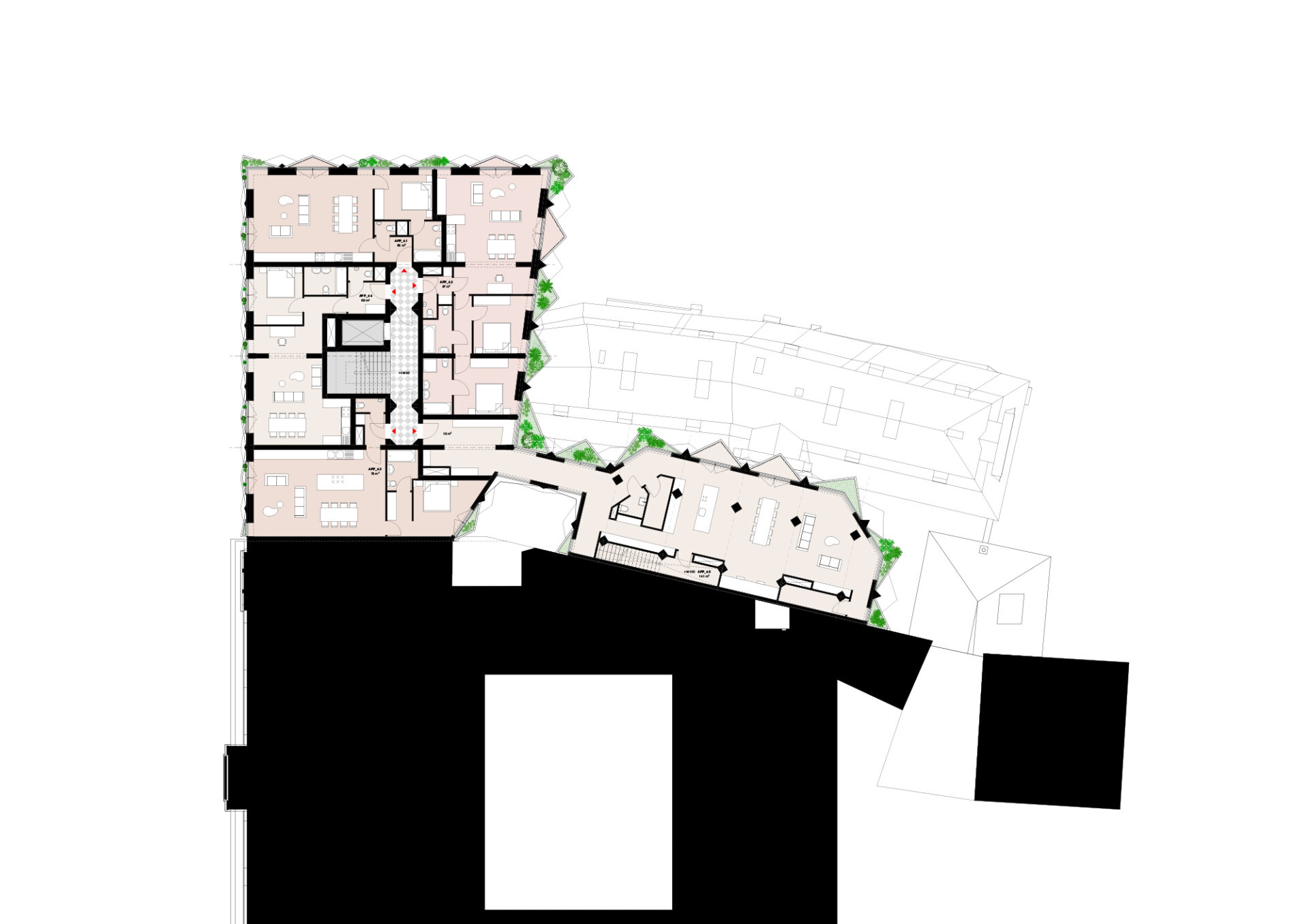
Schiehaven Noord
The masterplan for Schiehaven Noord capitalizes on the opportunity to further develop Rotterdam as a city on the river. It shows how inner-city densification of port areas can go hand in hand with creating high-quality public spaces and facilities that function both at the level of the city as that of the neighborhood. In its renewed relationship with the river, the neighborhood celebrates liveliness and urban connections as well as tranquility and intimacy. The plan is developed in close collaboration with the Municipality of Rotterdam and BplusB urbanism and landscape architecture.

The green urban plan provides for a varied mix of 1000 new homes, half at affordable and half at market price, thus making an important contribution to tackling the housing shortage through inner-city densification. The existing heritage (the Maaskant building with offices and the Marshall warehouse with cultural and social functions) are logically integrated in the plan and complemented with other strategically located public facilities in the plinth of various buildings.
A 40m quay extension makes it possible to combine the significant building program with a wide range of green public and collective spaces, as a welcome addition to the stony character of the adjacent Lloydpier and Müllerpier, and compensating for the wide area with underground infrastructure where no construction is allowed. Specific hindrances of this former harbor area such as the impact of wind and noise ask for an intricate urban fabric of medium height (instead of high-rise) that can provide shelter and security.


The urban design features a differentiated ensemble with a strong character, fabric and vertical silhouette. At the level of the city, the plan manifests itself as two superblocks matching the size of the port. On the scale of the neighbourhood, the plan reads like a sequence of green courtyards that together form a green residential fabric. On the scale of the building, a conscious effort is made to use a small grain that reflects the rich mix of residential typologies and residents, as well as enables identification with one’s own residential building.
Each layer of the plan connects to the city and the public space on a different level.
The superblocks relate to the two urban axes of the quay (Maaskade) and the dike (Westzeedijk) and as well as to the green connection on top of the underground infrastructure. The series of courtyards form wind and noise-free green collective spaces for the neighbourhood community. Finally, the individual buildings have addresses towards all sides so that the plan has no backsides. With carefully designed transitions between private, collective and public space, including raised terraces in front of the ground-floor homes, they contribute to the synergy between living and public space.


Within the range of Rotterdam’s (post-)industrial harbours, Schiehaven Noord is special because of its large contact with both the river and the dike. These two long lines of water and earth are used to give identity to the plan. A wide landscaped quay redefines Delfshaven’s relationship with the Maas by giving the opportunity to experience the river up close. The proposed new city square in front of the Maaskant building will have wide, sturdy stairs descending towards the water: De Maastribune. Existing and new sports facilities, as well as sunbathing areas on the quay, bring urban activity right down to the water. Natural zones and native plants are located both on and along the quay and reinforce the ecological position of the Lloydkwartier along the banks of the Maas.
At the other side of the plan, a differentiated urban facade is proposed along the dike. Ground bound dwellings with front doors on the dike alternate with apartment buildings with see-through entrance lobbies. This setup with addresses along the dike ensures liveliness and urbanity to this important scenic urban structure of Rotterdam.


The street between the two superblocks is an extension of the northly situated Oostkousdijk and Havenstraat in Delfshaven, strongly connecting the new neighbourhood to the inner dike city parts. This slow traffic axis connects to three parallel slow traffic routes: one along the dike, one in the inner area and one on the quay. They accentuate the characteristic longitudinal direction of the harbour and connect the Lloydkwartier with the former Schiemond port area and the De Kroon site. The car is given a subordinate place in the plan by accommodating it in two parking hubs on either side of the plan: a fully underground parking garage (2 layers) on the East side and a demountable multi-level parking garage on the West side. The quay and the dike route are only accessible to car traffic for the purpose of garbage collection, parcel services, moving and emergencies.


The project strives for a differentiated unity, both at the urban and architectural level. The two super blocks are made up of individual buildings placed next to each other, which clearly acquire their own character within a common architectural DNA. This creates a family of buildings that shape the quay, dike and courtyards by means of differentiated urban walls. In addition to the so-called “Rotterdam layer” consisting of 3 to 6 floors, the plan has a rich collection of higher volumes up to a maximum of 15 layers. The “Rotterdam layer” is oriented to the ground level and shapes the urban spaces. The height accents, situated in a checkerboard pattern, focus on the view and give the project its own distinctive skyline with staggered height accents.


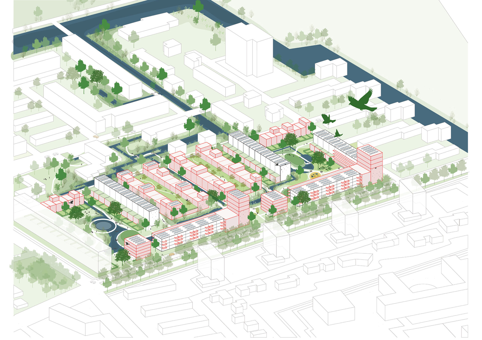
Westwijk Rooted
Westwijk, an icon neighborhood of post war urbanism, needs renewal. Both the original housing stock and the public space are outdated. The clear urban layout designed by Willem van Tijen offers a good basis to further draw upon. At the same time we will have to break with some of the original principles. We have to move form tabula rasa to tabula scripta and from a separation to combination. More specifically, this means that the relation between the residents (and their houses) and the ground has to radically change and that both the housing stock and the public space has to become more attractive, diverse and sustainable.
Westwijk Rooted is about a neighborhood that is linked to its reconstruction past, its wet soil, the adjacent polder landscape, the new metro station and of course with existing and new residents. A new ground level based on the wet soil condition forms the landscape framework of the plan. It makes the neighborhood climate-proof, water-resilient and biodiverse. At the same time, it creates the ideal conditions for attractive new living environments that are anchored in the ground level.
To help Westwijk and its residents take root, we use the following five strategies:
From floodings … to a climate-adaptive living environment
Westwijk was built in the 1950s on a thick layer of sand without any relation to the peaty ground. By excavating the sand layer in the public space, adding much more surface water to the neighborhood and raising the Krabbeplas area in strategic places, attractive and climate-adaptive residential environments with limited subsidence are created.
From isolated … to connected
In addition to the interweaving of Westwijk with the Krabbeplas recreation area, the connection with the new metro station must also be strengthened. What is needed is an entrance square, a station development with housing and an improvement of the north-south axis that also establishes the link with the Broekpolder.
From skimpy green … to green with value
By better attuning the greenery to the water-rich soil condition, less maintenance will be required and the ecological quality will increase. A greater biodiversity goes hand in hand with a more recreational qualities and attractive walking routes. The green can also be used functionally due to its water purifying capabilities.
From uniform housing … to a diverse mix
Our plan focuses on a varied housing stock with an emphasis on more ground-based housing in the private sector. In Van Tijen’s urban stamps, the necessary adaptions because of the energy transition are used to realize a combination of demolition, new construction, renovation and transformation. In the new development locations on the edges of the neighborhood, a combination is also being sought between homes for young and old, both in the private sector and in social rent sector.
From social isolation … to communities
We are committed to stimulating communities. Communities consisting of residents with a mix of economic strength, age and family situation. Communities that feel connected to their immediate living environment. In addition to the housing supply, the design of the public space plays a decisive role in the creation of these communities.
The deployment of the various strategies provides the ambition map for the Nieuwe Westwijk. This map is not a blueprint, but a dot on the horizon to work towards. Based on two prototypical case studies, we show how this ambition can be put into practice.

Wetering: Core of the neighborhood
In the core of the neighborhood, stamps with one-sidedly oriented residential blocks and an indefinable public space currently dominate the image. By demolishing part of the residential blocks and replacing them with ground-level homes and transforming some of the blocks into homes for families and the elderly, a rich mix of housing types is created. In the public space, a climate-robust, connective and biodiverse outdoor space is created by cutting roads, excavating soil and connecting waters. In the south a more urban wall is being created by the addition of life-course-proof apartment buildings.


Lage Weide: Connection with the landscape
The current situation is characterized by a hard division between landscape and neighborhood. They are separated from each other by a wide watercourse without bridge connections. Our approach is to interweave landscape and neighborhood and to connect both with the natural wet soil condition. This creates a connecting water landscape that forms the basis for new living environments. The current homogeneous housing stock in the stamps is supplemented with new housing typologies with an emphasis on ground-based family homes. To this end, both new constructions (after demolition) and transformation of the existing flats are applied. In order to create more water, ground is excavated. Excavated soil is used to create mounds for a mix of recreation and housing in the landscape.


Ring around Krabbeplas
In order to co-finance the large-scale transformation of the public area of Westwijk in particular, we see an opportunity to make a limited number of specific forms of housing possible in – and especially around – the Krabbeplas area. The condition is that living remains subordinate to recreation and that the residential buildings make a significant financial contribution to the transition of Westwijk. In addition to the residential enclaves located on mounds in the transition area between landscape and neighborhood, we are also providing noise barrier houses along the A20 in the north. Together with water houses on the west bank of the Krabbeplas and a series of CPO residential areas on the southern polder ribbon (Zuidbuurt), a new route around of Krabbeplas is created.


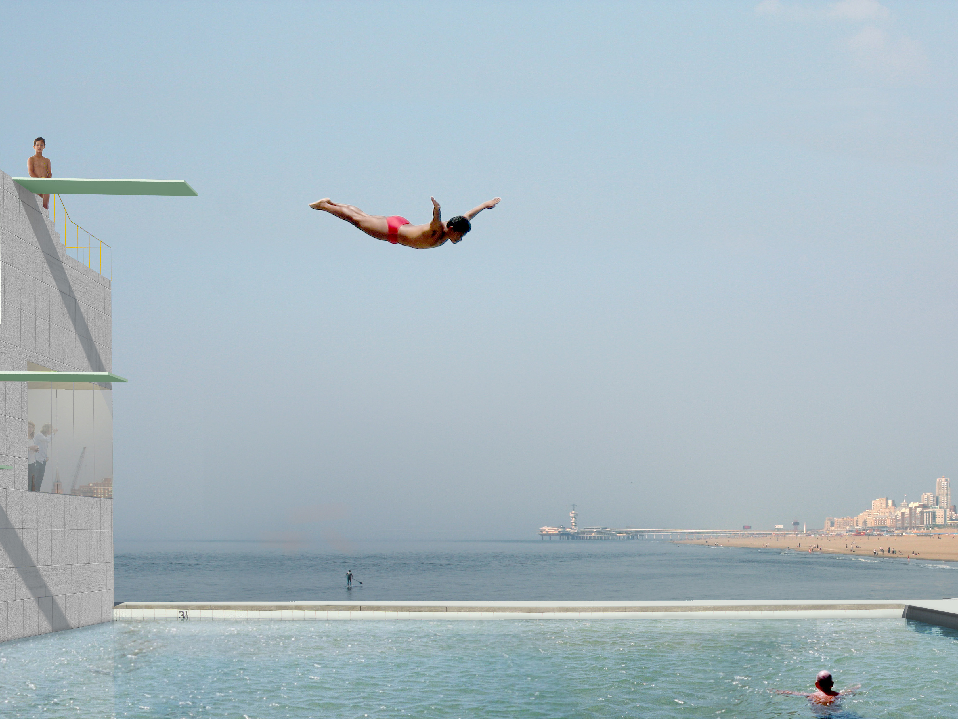
Beach City 2.0
In 2012 Shift architecture urbanism made a spatial vision for Beach City on behalf of the municipality of The Hague. Building on the study of Shift architecture urbanism, the Beach City Foundation has asked Shift to contribute to a supported programmatic vision for the total concept. All the different stakeholders (water sports, beach sports, boardwalk sports, catering pavilions and the stadium) were represented in drawing up this vision. Based on this programmatic vision, Shift has made a design proposal for the location in collaboration with LOLA landscape and POSAD spatial strategies. This design takes the extension of the Scheveningen boulevard as a starting point and concentrates a large number of different sports in a sports dune, a sports square, a sports boulevard and a sports quay.
The Beach Sports Accommodation (BSA) is central to the design. The BSA is the programmatic heart of the area and facilitates the various sports landscapes. In addition, it also facilitates the beach stadium that descends on the beach in the summer months.
The beach sports accommodation is a flexible building that enables a wide range of user scenarios, a contextual building that responds to the unique location on the beach, boulevard and sea and a connecting building that makes the link between the higher situated square and the beach and the various (sports) activities.
The building consists of two main functions: a permanent Beach Sport Accomodation (BSA) and a temporary Beach Stadium. The BSA functions as the center of Beach City all year round. Here are facilities for the wide variety of athletes who visit Beach City as well as other visitors. In addition to a sports canteen, the BSA houses multifunctional spaces that enable the building to accommodate a wide range of usage and exploitation scenarios. There are changing, shower and locker facilities specifically for athletes.
The Beach Stadium will be added to the BSA in the summer season, or will only be built at the time of major events that require such a stadium. It consists of temporary stands around a Center Court and is enclosed by a lockable boundary. This makes the stadium suitable for sporting events and other types of events that can be both freely accessible and “ticketable”.


The BSA is located at the head of the square, at the end of the new boulevard. This prominent position gives the building a landmark function for Beach City. A landmark that makes Beach City clearly visible and accessible from the Scheveningen boulevard, the beach and the sea. The positioning of the Beach Stadium on the sea side of the square guarantees the visibility of the BSA.
The BSA is an all-sided building consisting of four quadrants, separated by 2 axes that form a central hall in the middle. Each quadrant has its own function and shape that is derived from its specific orientation.
The quadrant, oriented towards the sea and the beach, contains the canteen whose round glass façade underlines the panoramic view. The quadrant aimed at the Beach Stadium is designed as a round bite out of the building that connects to the contour of the temporary stadium, which contains a multifunctional space that can be used as part of the canteen as well as separately as a skybox towards the stadium. The quadrant towards the boulevard and square contains a cluster of multifunctional spaces designed like a glass house. The quadrant towards the windward-facing part of the beach, where the permanent beach sports fields are set up during the bathing season, is designed as a grandstand with all the changing, shower and locker areas for the athletes underneath. These facilities are directly accessible from the beach via an entrance in the grandstand.

The two transparent axes through the building make the building publicly accessible from both the sports beach and the square. From the main entrance on the square one looks and walks straight through the building towards the open beach. The axis transverse to this also provides access to the building from the private part of the sports beach.

The grandstand makes the roof of the building accessible. This creates a public viewpoint from which one has a panoramic view of Beach City. By also making the roof accessible from the building, it is possible to design the roof as a terrace and multifunctional space during (sports) events.

Rozemaai at home
Rozemaai at home is a plan for 140 social houses, 30 medium-priced houses, a day care center, commercial facilities and an array of public spaces. The site is part of Rozemaai, a postwar extension district of Antwerpen in modernist tradition, that is undergoing a massive transition. A masterplan by Buro Lubbers for the whole district includes a new natural park along a re-opened creek, the Donkse Beek. The jury, chaired by city architect Christiaan Rapp, praised the way our winning entry – At Home in Rozemaai – relates to the fragmented urban context and in particular to the new landscape of the creek’s valley.
The main contradiction in social housing today is the tension between the necessity for standardization on the one hand and the need for identity on the other. Housing blocks, urban spaces, buildings and units should all be the same for financial reasons and all be different for socio-cultural reasons. Team BOGDAN & VAN BROECK and Shift A+U has chosen to explicitly use this ambiguity in the urban scheme, the building typologies and the architecture of their project for Veld 15a in Rozemaai.
Currently Rozemaai lacks any kind element in the public space that embodies the idea of community. The question therefore is how can we create a home, both on the level of the city and the house, that combines the suburban living qualities with a landscape design that is based on strong ecological connections and accessible green spaces of quality.
“Rozemaai at home” is the result of a search for an environment in which houses and inhabitant are part of larger whole, a Habitat. Neither the modern city with its isolated machines for living nor the traditional city with its perimeter blocks, streets and squares, provide the answer in the context of Rozemaai. The answer lies in residential buildings and inhabitants that relate in an alternative way to one another, to the ground and to the landscape.

The urban scheme consists of an ensemble of solitaire blocks and slabs which together form clearly defined public spaces that balance between open and enclosed. Because of their clear definition, hierarchy and function these so called outside rooms are clearly different from the flowing and desolate public spaces of the modern city around. At the same time this new urban fabric offers enough openness for the creek valley to be experienced from the houses and for this water landscape to physically enter the project. In this way the most important feature of Rozemaai, its creek valley, becomes an integral part of the daily living experience of the new inhabitants.


The proposed buildings have a relatively fine grain size. This results in public spaces and housing blocks with a human scale that allow for appropriation and identification by the inhabitants. It also leads to apartments with a lot of living quality in terms of light and view. All apartments in the blocks are corner apartment with a two sided orientation that offers views of two different outside rooms. The galleries in the slabs are relatively short and they are loaded with so called see-through apartments.

The outside rooms are clearly different in scale, function and degree of openness. The parking program is distributed across several small green parking’s along the perimeter of the site. In this way, large and desolate parking fields are avoided and in time, when car sharing becomes the norm, they can step-by-step be replaced by green. Each housing cluster has a central court with an enclosed character. The intimate quality of these residential courts is enhanced by a system of pergolas between the blocks that also articulates the entrance zone to the blocks. Lastly, a large multifunctional square connects both new residential clusters with each other and with the adjacent gallery flats.


By using a common DNA for the architecture, a family of buildings is created that clearly belong together but at the same time are all unique. Both the blocks and the slabs are based on a rational typological system that allows for high degree of variations in terms of apartment types. In the blocks, each specific configuration of apartment types leads to its own building mass, that subtly differs The rational facades balance between solid and transparent, creating both an analogy and a contrast with the radical transparency of the gallery flats by Kempe Thill with which the project clearly seeks a dialogue.


Batavialand
The Batavialand Foundation aspires to become THE museum in the Netherlands that portraits the origins of our national DNA, developed by living on the border between land and water. In order to achieve this ambition a large-scale expansion and transformation of the current museum is necessary. Shift architecture urbanism has been commissioned to do a spatial exploration that investigates how to translate the new Batavialand program into an architectonic, urbanistic and landscape design that does justice to this ambitious assignment within the context of the Lelystad Batavia quarter.


formal frame versus informal landscape
Batavialand will become a world in which the visitor is guided along experiences that feature the historical, current and future relationship of water versus land in the Netherlands. This time travel runs through the recreated historical landscapes of the prehistoric creeks, Flevo Lacus of Roman times, the Zuiderzee in the Middle Ages and finally the international exploration of the world’s oceans with the Batavia ship as a highlight. Subsequently the present and the future are presented, in the form of a manufacturing landscape, a shipyard, and an information center where companies in the field of water management demonstrate their current and future knowledge and skills.

Our proposal consists of a fixed, uniform and formal framework that encloses a flexible, differentiated and informal world. This frame both unifies and separates. It unifies the varied parts of the museum by embracing the different landscapes and by connecting the different buildings. It separates by defining a clear limit between museum and its surroundings, creating a clear entity towards the outside and an introvert inner world that lends itself for a varied collection of simulacra that recreate the Dutch relation of water and land over time. By incorporating the public promenade that runs right through the museum, the clear division between inside and outside is locally released. Here, museum and city are intertwined.

The frame contains a covered walkway that opens inwards and has a more closed character towards the outside. The formal indoor route it creates contrasts with the labyrinthine outdoor routes through the landscapes it surrounds. The visitor can freely switch between these two ways of navigating the museum.Both existing and new buildings are situated on the inside and on the outside of the frame. Within the buildings there is room for museum experiences with more depth and reflection; in the framed, free outdoor space there is room for play, infotainment and discovery.

CultuurCentrale
The CultuurCentrale proposes a rehearsal accommodation for dance and theatre in the so called Ebbingekwartier, a former industrial area in the city center of Groningen. The location is situated next to the old Machine Factory, which is already in use as a dance and theatre studio. The new accommodation should house four different companies which are currently scattered around the city.
The assignment has a somewhat ambivalent character. The different accommodations should together function as a site-specific ensemble that revitalizes the area with cultural activity. However, the future program is rather closed (dance and theatre studios) and each company prefers to maintain its own identity and a maximum amount of flexibility to adjust their accommodation within the complex.


CultuurCentrale proposes a compact and rational building that maximally opens up towards the ‘route van de ziel’, a public route that connects the different historical remnants of the Ebbinge Kwartier. The building is perceived as a factory. Apart from the reference to the history of the site, the archetype of the factory hall fits perfectly with the demands for rehearsal studios for dance and theatre productions: large column free spaces that are flexible in use and have a functional and no-nonsense finish. Also, the compact and rational setup of the building answers to the complex urban situation, the tight budget and the ambition for a net-zero energy building.
The building is set up as a linear series of programmatic zones for studios, offices, dressing rooms and foyers. The three largest studios are placed upon the smaller studios and storage spaces to create a compact and structurally logical configuration. Underneath the cantilevering large halls is a 6-meter-high zone with offices, facilities and foyers.

All four entrances are situated along the route van de ziel and open up generously towards the surrounding public space. A strip of facilities (dressing rooms, toilets and kitchens) separates the public entrance zone from the rehearsal studios. The offices are situated on top of the facility zone and look out over both the entrance and the rehearsal studio’s. The rational linear layout of the building allows for a lot of cross-overs between the different companies, and introduces a maximum amount of flexibility for the wishes of the different users, now and in the future.


Plans

The concentration of all circulation space in the double high foyers creates a very spacious and lively entrance for all four institutions. The high glass facades enhance the openness and interaction with the surrounding city and create a clear individual entrance for each company.
The partition of each programmatic zone is flexible and differs per zone. Only the walls between the rehearsal studios are loadbearing, creating a lot of freedom to adjust the individual entrances, facilities and offices to the wishes of the different institutions.

Along the new building the route van de ziel will be designed as a multifunctional square that can accommodate exterior cultural functions and events. The public square forms the connection between the different companies and creates an urban ending to the route. The pubic space within the ensemble becomes part of the shared domain of the different cultural institutions. Bordered by the existing monumental factory wall on the one side, and a new pergola on the other, the area will be designed as a green garden with outdoor work and meeting spaces.

The architectural appearance of the building seeks a balance between the continuity of the existing city and the industrial history of the location on the one hand, and the recognizability of the new on the other. The facades are composed of brick, resembling the existing Machine factory, but the appliance of the material is consciously different in both color and type. By using wire-cut brick and white seams in a tiled pattern a contemporary and industrial look is created with a graphical quality that forms a subtle contrast with the traditional brick architecture of the Machine Factory. On the first floor the facade flips from a horizontal to a vertical pattern. This creates a double high plinth that subtly refers to the internal organization of stacked halls inside the building.


For the interior, the analogy with the factory is continued further by using industrial materials that are selectively (un)finished. There is a clear contrast between the interior of the entrance area, and that of the rehearsal studios.
The flexible interior of the foyer, facilities and offices consist of light walls which are clad with panels of underlayment. Each institution is free to appropriate these spaces, creating a clear and distinct identity for each individual organization in the building.
The concrete walls of the rehearsal studios will only be finished there where acoustically necessary. From two meters upwards the walls will clad with a theatrical padded surface which contrasts with the atmosphere of the industrial hall. Also, the curtains have an acoustic effect and add to the contrast between theatre and factory.


5TRACKS
Following the arrival of the high speed train from Amsterdam, the entire station district of Breda has undergone a complete urban renewal. The new world-class station terminal now bridges both sides of the rails, connecting the previously isolated northern side of the city in a seamless way to the historical centre. That gives the chance to redevelop the (former industrial) sites situated north of the rails into a prolongation of the city centre, a new meeting place of the city. 5TRACKS is one of them, forming the final piece of large scale development on the west side of the station (urban design by Claus en Kaan architecten, 2010). It accommodates a mixed program with living, working, recreational and commercial facilities. The high density and varied program creates a dynamic city environment which promotes the sharing of facilites by different users and urban encounters.

5TRACKS is designed as an ensemble of three buildings with two identities: one towards the city and one towards the railway. At the north side, along the new Stationslaan, the ensemble presents itself as a continuous city wall that relates in scale, material and height to the oppositely situated neighborhood Belcrum. At the south side, along the train tracks, it features a sequence of higher triangular buildings in a park, aligned like a zigzag “hedgerow landscape”. The design follows closely the guidelines of the masterplan by Claus and Kaan architects, which envisioned the “hedgerow landscape” along the railway as a means to create a qualitative entrance to the city. This artificial scenic landscape formed by buildings and vegetation elements in the park ensures depth and a layered perspective for the train passenger and a green buffer for the users of the buildings close to the rail.


The spatial and programmatic organization contribute to the two-sided orientation of the plan, activating both the street side and park side. A unitary plinth with bars, restaurants and other commercial functions towards the Stationslaan makes for a lively route in between the station and the Court building, situated further to the West. Behind it and stretching until the rails, a parking garage occupies the entire ground floor. On top of it, three triangular building blocks house offices and the hotel. Their northern façades build up the 16m tall profile towards the Stationslaan, while the southern façades create the zigzag “hedgerow” structure, which opens up with collective facilities towards the park. The triangular blocks are topped by V-shaped slabs towards the park which contain different types of apartments and hotel rooms. These are all oriented to optimally profit from the sun and view towards the historic centre of Breda and make use of the collective gardens on the roof of the triangular blocks.


plans
One of the challenges of the project was to make sure that the park is not just a decorative piece of green trapped in between the buildings and the rails, but an integral part of the city.
The organization of program in three distinct buildings leaves room for generous connections between the Stationslaan and the higher situated park. The height differences are bridged by inviting stairways and ramps where the vegetation is literally pulled down to announce the park at the street level. The parking deck is covered with a 50cm -90cm earth substrate in which a vegetation of grasses and groups of birch trees are ordered to form the hedgerow structure. Several thematic squares featuring terraces, outside working and meeting places charge the park with activity.


Additional to the public connections in between the volumes, each buildings has a central atrium which relates to both the park and the street. The atria are conceived as voids sculpted in the building mass and separated from the outside with very transparent facades, so that indoor and outdoor run seamless into each other and the park and the city literally meet. The various collective facilities situated here provide synergetic moments where the resident, the entrepreneur and the passerby come in contact with each other.


Within the project, recycled ceramic stone strips from Stonecycling will be applied on a large scale for one of the first times in the Netherlands. With this application, around 385,000 kilos of construction waste material will thus be incorporated into the project’s facades. The wide variety of “masonry bonds” maximises the potential of the stone strips. The use of sawn strips makes full use of the bricks, but also creates a differentiated image of baked and sawn strips in the façade.


Museumplein Limburg
Museumplein Limburg is a trinity of complimentary museums combining design, science and technology in one museum district in Kerkrade, a town at the Dutch-German border. The existing Continium (a discovery centre for science), has been extended with Cube (a design museum consisting of exhibitions and exploratory labs) and Columbus (housing a unique Earth Theatre and a 3D cinema), as well as a wide range of public facilities for events, workshops and education.
Capitalizing on the strategic location, the museum quarter formalizes the entrance into Kerkrade for both train passengers and visitors arriving by car from the main access road.

The brief required the extension of the existing museum with two new institutions, each with an own identity, but which can also function as a whole. Our answer is an ensemble of clearly recognizable volumes connected by an elaborate underground public space.

Above ground, a cube and a sphere, spectacular in their absoluteness, provide the two new institutions with distinct identity. With their pure geometry and omnidirectional orientation, the cube and the sphere counteract the amorphous and introvert character of the existing museum. However, their iconic character doesn’t make them into isolated urban objects. Together with another primary solid, the 80m long beam which doubles as a giant canopy, they are carefully placed in relation to the nearby station to articulate the public route between the station and the city centre. On this public walkway, the volumes reveal themselves towards the pedestrians with lively areas such as the entrance hall underneath the beam and the design labs underneath the cube.

Underground, the sunken square, the best feature of the original museum, is extended underneath the new volumes. A continuous landscape is created that connects all the facilities of the museum district, both old and new, and allows them to function as a single whole.


The new enlarged sunken square forms the heart of Museumplein Limburg. It extends seamlessly underneath the beam that hovers above the double height entrance hall. This linear entrance hall serves as the logistic backbone of the whole museum district. Visitors descent via one of two wide staircases at both ends: one orientated towards the train station and the other towards the town’s centre.


In addition to the new museum square and entrance hall, the underground landscape hosts a restaurant, an enclosed patio and two tunnels connecting to Cube and Columbus.


All stairs, walls and floors of the underground landscape are made of a uniform earth tone concrete to emphasize the connective character of the space and to create the suggestion of an excavation. The walls were poured in a formwork of rough wooden planks adding a tactile quality that contrasts with the abstract volumes above ground. The excavation out of red concrete, combined with the experience of descending below ground, refer to the mining past of Kerkrade.


Floorplans

Content-wise, Museumplein Limburg aims to be a “museum without boundaries”. As opposed to the static vision of the museum as an island offering a passive escape from reality, the “museum without boundaries” is an interactive workshop where visitors are regarded as participants rather than spectators. They discover the world and their place in it through interaction, participation and debate.
Our ambition was to translate this concept architecturally by blurring the boundaries between museum space and public space, and make Museumplein Limburg an integral part of Kerkrade.

By situating a large portion of functions underground, the built footprint on the ground level was minimized, thus leaving space for public walkways to criss-cross the museum district. The route to and from the train station, designed as a scaled up zebra crossing, creates a visual dialogue between the museum district and station area and adds to the experience of both the museum visitor and the train passenger.

A transversal walkway, punching through the entrance hall, connects the sunken museum square to the district’s bus terminal in the forecourt. This walkway provides train and bus passengers direct access to the museum’s restaurant which can double as waiting room, transforming the museum square into a true extension of the public realm of Kerkrade.


The combination of public space and public transport with the museum district fits perfectly with the ambition of a “museum without boundaries”: even passers-by become participants.


CMY pavillion
The CMY pavilion transforms the glass structure of Tschumi into a three dimensional graphic work that shifts its composition and color scheme with the viewpoint of the spectator.

The Tschumipavilion was originally built as a video pavilion for the city-wide exhibition-event “What a Wonderfull World” in 1990. Scattered around the city, five pavilions brought pop-music videos into the public realm. They were designed by the architectural avant-garde of the time, labeled two years earlier as ‘deconstructivist’ by the MOMA. The pavilions of Eisenman, Hadid, and Himmelblau disappeared, while the ones of Koolhaas and Tschumi remained.
Remarkably, it is OMA and Tschumi’s very different approach to program that have made their pavilions last. OMA’s programmatic alchemy, pairing of the pavillion with a bus stop, is the reason it survives today. Tschumi’s pavilion has persisted precisely because of the opposite reason: its lack of any precise program. Being a transparent envelope, it has been used as a public/urban event-space for temporary art projects since 1995.

In the middle of a busy roundabout in Groningen, Tschumi created one of the most transparent buildings ever built: its facades, roof as well as structure are made of clear glass. Tschumi chose glass for its reflective quality to create “instable facades” that would reflect the video images endlessly. These videos transformed the “invisible pavilion” into an “illusionistic spectacle” in which the virtual image from the reflections mix with the real image from the monitors and the city.

Shift’s intervention reinterprets the idea of “instable facades”. Instead of using the glass envelope to mix videos, the CMY pavilion uses the glass to mix colors. By applying translucent films in the colors cyan, magenta and yellow onto the glass, the pavilion turns into a three dimensional graphic piece that changes continuously with the movement of the spectator.


The colored pattern of diagonal bands that wrap around the building is derived from the rigid paneling system of the structure. Because of the parallel transparent facades, the color bands start mixing according to the subtractive color model. The overlap of the “real” primary colors on the glass create secondary “virtual colors”: C + M = Blue, Y + C = Green, M + C = red. The transparent pavilion becomes a dynamic color space with a strong urban presence.

From different angles come different experiences of the CMY pavilion. People circulating on the roundabout will experience continuously changing colors and patterns. Standing on the square facing its long side, one perceives a cross-hatch pattern in six colors (CMYRGB). One waiting for the bus with an oblique viewpoint sees the “actual pattern” of diagonals in three colors (CMY).

Inside another appearance is uncovered: here the colors mix with the city rather than with each other. Since there is no more overlapping of colors, the diagonal CMY color bands are clearly visible. Their diagonal wrapping enhances the destabilizing, girating effect that Tschumi intended by tilting the building.


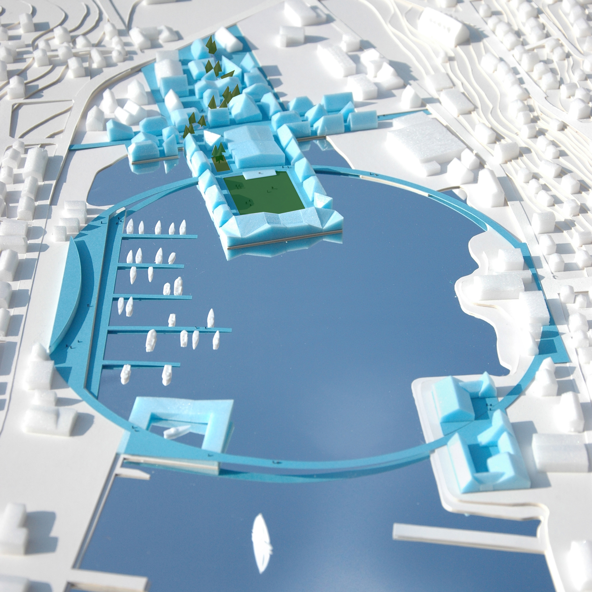

Klaksvik United
Klaksviks sublime location has become its weakest link. Present day Klaksvik is a spatially divided town. Ironically it is precisely the spectacular estuary location, and the way it is occupied, that causes this separation. Both the bay and the central isthmus act as barriers that split the town into two linear settlements with little connection to the water.

Our proposal, Klaksvik United, aims at creating a new town center that unites Klaksvik with itself and its waterfront. Two strong forms, a ring and cross, are used to transform the open water and the empty center from barriers into connectors and from non-places into places. They function as fixed armatures for flexible city center developments. Their unifying gesture opposes ánd incorporates the urban fragmentation of the site and creates multiple links between east and west, north and south, water and land, old and new. The new center makes Klaksvik into one and celebrates its unique location.


The Ring reinforces Klaksvik’s relation to the sea by connecting both parts of the town an uniting them with the water. It functions as a pedestrian boardwalk of exactly one kilometer long that links a variety of waterfront programs, both new and existing and defines a new water square. In a mere 10 minutes walk one can experience the vital role that the sea plays for Klaksvik. The ring connects the outdoor event area of the new cross with the existing marina, the ferryboat terminal, the second landfill and the existing shopping street on the south bank.
The ring transforms the bay experience into Klaksvik’s main asset.

The Cross, consisting of various spatial typologies designed to minimize the disturbing winds, establishes two crucial connections.
Main street runs from North to South and connects the separated halves of Klaksvik. Its mixed use program of retail, services and housing creates a lively street that forms the backbone of the cross development.
In the other direction, a central square with public facilities and a wind free labyrinth neighboorhood connect the green isthmus with the bay and reestablish the relation of the old center of Klaksvik with the water. The central square is surrounden with a multifunctional event hall, the administration building and the tourist information, which protect it against the wind and use it to program cultural outdoor festivities, year round. The intimate and wind free labyrinth invites for strolls along its shops. Existing buildings are integrated in a compact urban tissue. The small block size allows for a flexible infill with a variety of retail and leisure programs combined with housing.


Studio Sport
With Studio Sport, Shift architecture urbanism shows how, where and why sport should be mobilized to boost urban quality. The result is a plea for hybrid urban sport places that are spatially and programmatically integrated in the existing city. They release sport from its isolated position, introvert character and mono-functional programming and charge the urban landscape with meaningful new places of (inter)action.


traditional city vs. sports city
Sport is sexy and it’s everywhere. It is connected with fashion, music, lifestyle, media, the street and the city. If sport was once the exclusive domain of clubs and associations, these days it is an indispensable part of our society and daily life.

In recent years, sport has developed from a goal in itself into an instrument. An instrument for policymakers to reach social targets, an instrument for commercial sport organizations to earn money and an instrument for municipalities to develop city marketing. Every Dutch city wants to be a sports city, or even thé sport city.

Sports and sportspeople are moving ahead too. The number of sports is growing fast, as is the so-called non-organized, spontaneous practice of sport, which takes place outside the context of the club, within the public domain of the city. This trend is expected to continue, as it corresponds to the need for flexibility of the modern urbanite.

Sport’s value for the community and the economy is getting major coverage in politics, the civil service and the media. Sport is good: good for your health, good for social cohesion, good for your image. Strikingly enough, the so called instrumentalization of sports has been overlooked by the spatial disciplines. Sport is subject of rest planning and its value for the city and its public domain is unexploited.

In the modernist city planning sports parks were allotted a place in the green zones sometimes in but more often around the city. The sports park was a way of escaping the hectic city.


In later urban urban expansion schemes many sports facilities had to make way for new residential and work areas. As a result sports parks shifted ever further outwards to end up in isolated leftover areas and ragged edges of the city, often right up against motorways or railways.

This back-seat status held by sport in spatial planning has led to the ‘islandisation’ of sports that is completely at odds with the development of sports itself and the social and economical roles it got assigned by the outside world.

High time then, that sport’s key place in society is reflected in the way it is designed and integrated in the city. The question is what sport can mean for the city and, conversely, what the city can mean for sport. Sport can benefit the city and its public domain. It provides a counterbalance to the impoverishment of public space by charging it with activity and dynamic. Sport is one of the most powerful means to get people out of their protective home environment during their leisure time. It provides frameworks for encounter and interaction, two prerequisites for a vibrant public domain. In addition, qualitative sport facilities enhance a city’s attractiveness as a place for companies and residents to settle.

Also the city has to offer quite something to sport. First of all, large groups of city dwellers would like to sport close to where they live, especially in the “problematic urban neighborhoods”, where car mobility is limited and there is a large demand for sports. Secondly, the city provides the possibility to connect sports accommodations, that generally have a low intensity of use, to other urban functions in the field of education, culture and neighborhood facilities. Smart programmatic synergies lead to a substantial intensification of sports use in space ánd time.


In a series of concrete case studies in Rotterdam, The Hague and Amsterdam, developed in collaboration with the municipal departments of spatial planning and sports, Shift has explored the Dutch city for its potential to integrate sport on a structural level. The issue on the one hand is to stitch existing, often isolated sport locations to the city and on the other to integrate new sports facilities in the city.

The case study projects have resulted a new kind of urban typology: the hybrid urban sports place. In these places, several sports are combined with each other and with other urban functions. Their hybrid character is reflected in the balance that they seek between formal and informal, top-down and bottom up, commercial and public, inside and outside, sports and other programs.


They are designed as urban landscapes with an open and flexible character, rather than closed utilitarian facilities. They function on the level of the neighbourhood, the city or the region, depending on their size, program and position in the city. Despite their speculative character, the proposals have a high level of realism and they react to concrete urgencies. Three case-study designs have led to further spatial and financial feasibility studies, commissioned by the municipalities or other stakeholders.


In addition to the case study projects, the website sportspace.eu was developped. SPORTSPACE is an online platform about urban sports spaces. The website collects reference projects of sports and movement spaces that are successfully embedded within the city and connects these with spatial design tools. It functions as a source of inspiration and a frame of reference for everybody who’s interested in the potential of sports for the city and vice versa.

The full body of work of Studio Sport was exhibited in the New Institute (former Nai) in Rotterdam. The exhibition was openend during a conference in which specialists from the domain of sports and space were triggered to participate in a constructive dialogue.


Binnenrotte SportSquare
Twice a week, the Binnenrotte accommodates a large market. The rest of the week, it forms a huge strip of emptiness at the heart of the city centre. On these days, Rotterdam’s largest square hopelessly craves for activity.
This project capitalizes on the Binnenrotte’s unused potential. It transforms the square, on days when there is no market, into thé metropolitan sports place for all Rotterdammers: a place for jogging and skating, football, tennis and hockey; a place for sports clinics, tournaments and gym classes of the surrounding schools; a place for informal activities, play and cultural manifestations.


marketsquare vs sportsquare

In order to guarantee the multiple use of the square, a specific sport toolbox has been developed. Its tools enable the continuous metamorphoses from a market square into a multifunctional sports square and vice versa, all week long, year-round.


Toolbox to transform the Binnenrotte from a market into a sport square and vice versa
An 800-metre urban athletics track encircles the square. It functions as a shared space for pedestrians, joggers, bikers and skaters.

Two multi-sport fields out of concrete are enclosed by a pergola structure with motorized curtains that automatically descend on sport days and retract on market days.


“curtain” fields
Two moving platforms – continuing a Rotterdam tradition that includes the nearby vertical-lift railway bridge De Hef – accommodate sports activities that require a surface other than concrete.

One consists of an artificial grass platform with variable positions: set at ground level on sports days; lifted to form a covered market space on market days. The other structure features a covered artificial ice rink, with a roof that descends to ground level to become a wooden deck on market days. Finally, a sun-oriented stand accommodates a clubhouse underneath, with space for locker rooms, showers and the offices of both the square’s sports and market manager.


moving artificial grass field
The Binnenrotte Sports Square lives up to ‘Rotterdam’s Sports City’ ambition and injects the city centre with the much-needed activities other than consumption.


Sportspark Escamp
Sportpark Escamp is a prototypical modernistic island-like sports park, situated right in the middle of a post war extension neighborhood: introvert, isolated, mono-functional, with a low density and intensity of use. Most of the park is occupied by football fields out of natural grass. They are used mainly on weekends and in the evening. The rest of the time the park is empty and inaccessible.

This project turns Escamp into a multifunctional urban sports park that combines a variety of outdoor sports with recreational facilities and routes that are strongly linked to the surrounding urban fabric.
By introducing football fields out of artificial grass – which allow for a more intense use – space is liberated for new functions without sacrificing the football-capacity of the park. The intensity of use is further strengthened by the addition of extra sports facilities (tennis, skateboarding), a play garden, and a school with daycare that uses the sports fields for gym and their annual sports day. These programmatic interventions strengthen the neighborhood function of the park and animate it also during weekdays and at daytime.


From monofunctional, isolated sport park, to an integrated sport neigborhood park
A new system of elevated routes, which continue the pedestrian network of the surrounding neighborhood, opens the location for recreational use. This public armature is designed as a body of earth that incorporates functions like parking, dressing rooms, storages and tribunes.


It creates two park levels: a lineair and informal park on the same level as the surrounding neighborhood and a sunken and formal park with several well defined outdoor sports fields. This landscape concept guarantees attractive visual relations between athletes, spectators and people strolling through the elevated park.


Sport Axis


from an archipelago of isolated sport enclaves to a Sport Axis with integrated sports facilities


Skate off the art
The existing skatepark Westblaak is at the end of its lifecycle. Its skate objects are outdated and do not meet the requirements of many skaters any more. They dislike the prescribed movement that the objects imply and prefer a park in which skating merges with public space and street furniture. Also the mono functional character of the place is considered as problematic by the municipality.


The project proposes a hybrid concept of a skatepark and a sculpture garden. It forms a new art route that anchors the project into the area’s cultural profile and attracts a larger public than skaters only.


The design consists of a three dimensional edge that defines a series of chambers that fluidly morph into each other. This spatial armature serves as a skateable edge, a green buffer that separates the park from the road and a sitting area for the spectators of the art and the skaters.

In the chambers, a variable collection of ‘skate-off-the-art’ objects is placed. They are designed by the skaters in collaboration with artists and local manufacturers. Their specific design triggers different forms of skating, without imposing a specific skate moves.

The skate sculptures introduce a collection of ‘use art’ that, like in the neighbouring galleries and museums, changes regularly. The park’s continuous renewal enables it to remain attractive and exciting for skaters and the public over time.


Park City


OPEN specifiCITY
The open city stands or falls on the way it manages the organisation of diversity. Our heterogeneous society demands a planning regime that shapes the exchange between and the overlap of different worlds. The public domain, in particular that of the square, is typically the place where contact between different sections of the population is stimulated and forms of new collectivity take shape.
In order to redevelop the square into a social space that ties in with the reality of the open society and that of the network city, we must introduce new types of buildings and squares. These types must be at once open and specific: open to different groups of users and uses while at the same time specific enough to produce the necessary differentiation and identification.

The Western Garden Cities, are being transformed with little regard for the original qualities of the modern city. The open structure of the initial General Extension Plan is replaced by a defensive form of urban planning that sources its ingredients from the pre-war city. Parks are fenced off, flats are replaced by perimeter blocks and open squares are redeveloped into indoor shopping areas.
The result – a patchwork of gentrified enclaves – may be filling the indeterminate open space of the original city, but is incapable of accommodating new forms of collectivity.

The brief for the August Allebé Square offers the opportunity to formulate an alternative strategy for the ‘problematic legacy’ of the modern city that failed to respond to demographic developments. This must be a strategy that sees the open city and its diverse population not as a problem, but as a chance to forge new types of collectivity and urbanism.


The design proposes a new spatial and programmatic composition that opens up radically on the levels of both neighbourhood and network city.
The potential of the square’s strategic position between the regional axes (A10, metro and train) and the major thoroughfare (Postjesweg) is capitalized on by spanning the square in between these different axes and introducing programs that are relevant on both regional and local levels.

In order to program and differentiate the larger space of the square, while at the same time safeguarding its openness, a new type is introduced: the so-called ‘pleingebouw’ (square building). An amalgam of building and public space, the square building is capable of adding programmed mass as well as charged emptiness to the square as a whole.
In dialogue with the existing buildings and/or embedded within the infrastructural network, a sequence of square buildings will enrich the open space with a number of urban archetypes (the podium, the colonnade, the canopy, the plan oblique and the frame).


snake


collonade


podium


table


labda


oblique plan
The result is a square-within-a-square-situation, which can simultaneously accommodate different groups and activities without disrupting the continuity of the open space.
The explicit programming of the masses (public transport, commerce, culture, community and sport) and their specific design imply the use of adjacent public space without fixing it. There will still be room for improvisation, spontaneity and the appropriation of the squares by different groups.


The August Allebé Square in its entirety is more than the sum of its individual parts: the co-existence of different groups and their activities transforms the square into an urban “coulisse landscape” where one is constantly reminded of the presence of parallel worlds, of ‘the other’.


M3

Lunaparking


Exorcizing on Communist Hardware

Beach City
The brand new boulevard of Scheveningen lacks a clear ending at its south side. The promenade runs dead into a rather desolate area with a sport beach, a harbor and a sort of free zone of parked cars and a surfers village. The sport beach has little articulation, consistency and allure.

During the summertime several national and international beach tournaments are held in a temporary stadium on the beach. The current stadium lacks charisma. It’s a closed structure with an uninviting facade. The municipality wants to explore the possibilities of a temporary stadium that will be able to activate the beach year round.

This project transforms the current sports beach into a ‘Beach City’ that bundles beach and sea related sport facilities, both existing and new. Beach City activates the southern end of the Scheveningen boulevard with a sportive hotspot that functions on a regional scale


The design introduces a fixed and permanent armature for flexible and temporary Beach City developments. This armature consists of the prolonged boulevard that is deformed into a toothed shape in order to enhance its relation with the beach and to create docking stations onto which a flexible set of plug-and-play facilities will be attached. These facilities differ in time, according to season, demand and event calendar. The armature itself incorporates permanent facilities such as toilets, locker rooms, showers, storage spaces, a bar/restaurant and a water sport coordination center.


Sports beach seen from the boulevard


Sports beach and beach stadion seen from the harbour pier
Beach City accommodates a large variety of plug-and-play facilities: both new and existing, both public and private, both beach and water related, both temporary and semi-permanent. The surfers village and the beach stadium will be the main players that are already active in the area. Potential new plug-and-play facilities consist of a muscle beach, a climbing beach, a skate facility, a tidal swimming pool and a multi sports field. Many of these facilities will reduce in size or entirely disappear in winter. Then beach city will again be the domain of the hard core kite and wave surfers that have appropriated the site in the first place.


Dealing with Vierhaven

Living apart together
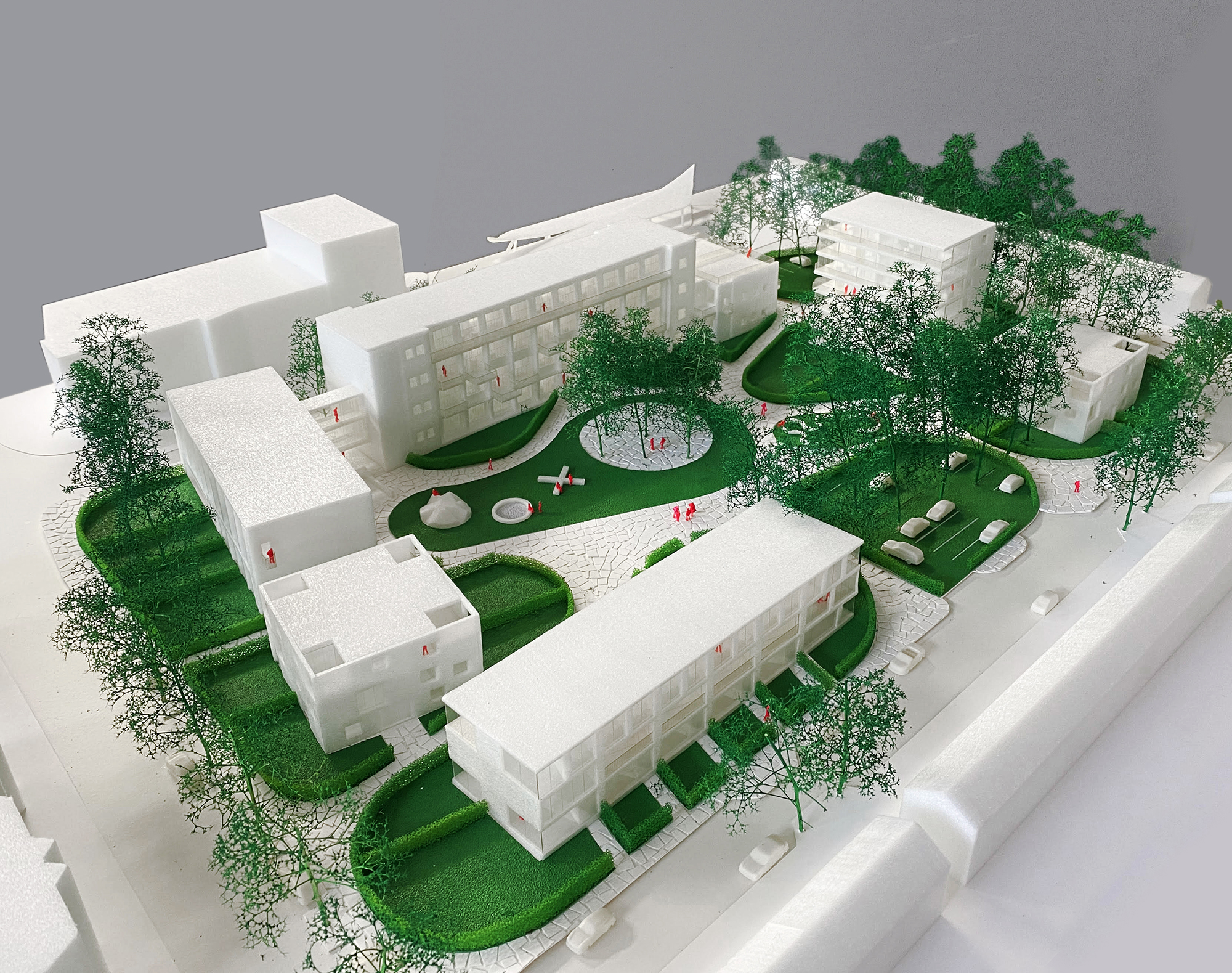
The municipality of Waalwijk selected six national developer/architect teams to envisage an urban vision for the redevelopment of De Walewyc School location into a specific, differentiated and high profile living environment.

In order to fulfil this ambition, we found it essential to reconsider the municipality’s suggestion to demolish the existing school buildings. De Walewyc School is an icon of post-war reconstruction architecture in a surprisingly good and original state. Besides the cultural and historical value, a building’s potential for future uses should determine the choice for demolition or conversion. The former school’s urban situation, its transparent architecture, high ceilings and internal layout create the premises for a unique housing ensemble with spatial qualities difficult to match nowadays.


Scheme
Our proposal preserves the school’s three original buildings and adds four new ones around the former schoolyard. The building volumes form a permeable ring of solitaires that – together with the row of existing trees – define the limits of a public park (the former schoolyard). The volumes are positioned in such a way that the park is visible and accessible from the surrounding neighbourhood without losing its strong definition. By replicating the existing volumes’ DNA into the new ones, a family of buildings is created. This family has two generations, three volume sizes and several housing typologies, derived from each building’s specific orientation. The building solitaires are imbedded in an archipelago of green islands, consisting of public green, private gardens, and parking pockets. The green islands manifest themselves beyond the ring of buildings towards the surrounding streets, emphasizing the park-like character of the entire development.
The School

The existing school lends itself perfectly for appartments. Luxurious high ceilings, a corridor to the north and large windows to the south. Simply adding balconies and (roof)gardens to the building is enough to convert the school building into a rich collection of different typologies.


School New Floorplan

The Row Houses

The row houses are designed as back to back houses. Each floor flips to the other side of the block, creating houses that are orientated towards the park as well as the street.


Mirroring floor plans

The Block

The small blocks are designed as helix houses: each floor of the house jumps to the other corner, creating houses that touch each corner of the block: 360 degrees orientation towards the park as well as the street.


Rotating floorplans

The Tower

The apartment tower is dived in two halves: a closed part that houses the night program and an open part, orientated towards the park and the sun, that houses the day program.


Floorplans


Topos
Landgoed De Groene Kamer seeks to develop a new type of country estate in the southwest of the city of Tilburg where eco-retail, nature and recreation are brought together. A place where city and countryside meet, both physically and programmatically. Shift’s proposal, Topos, focuses on a radical integration of architecture and landscape.


Masterplan
Topos transforms the flat body of earth in the existing master plan of .Fabric and LOLA into a differentiated earthwork. The boulevard, the squares and the buildings are placed in and on this earthwork. The body of earth is used as an instrument for place making and therefore becomes topographic. Each retail cluster is embedded in a specific three dimensional earth shape to create a sequence of differentiated places (topos). Shopping on the green boulevard becomes a natural experience in which the division between city and countryside, between architecture and landscape, is dissolved.


The entrance square is formed by a bowl-shaped earthwork which opens towards the parking arboretum. The circular shape embraces the visitors and welcomes them into a different world that invites for exploration. The various buildings situated in, on or under the earthwork bowl can be accessed from the square. Each building typology has its own specific connection with the earthwork and the surrounding landscape.
Block

The block houses a so-called landwinkel, a large shop where local food products are being sold. It functions as one of the anchor programs of the whole Groene Kamer development and is therefore prominently placed on top of the earthwork. The omnidirectional block manifests itself as a transparent greenhouse with a “wooden sculpture” inside.

This sculpture is designed as a cross shaped volume which allows for open corners in the building. The corners function as indoor gardens that literally bring the outside inside and vice versa. The cross volume is carved open on the ground floor, introducing a continuous and flexible floor plan that connects the corner gardens.

Campus

The campus is designed as a distinct and recognizable cluster of three retail buildings, literally embedded in the landscape. The entrances of the buildings are oriented towards the inside of the campus, to create a shared court that seduces the visitors inside. All buildings have a maximum transparency towards the shared interior. The other, more closed, facades are provided with a continuous horizontal strip window that follows the topography of the earthwork. This strip window introduces a new “constructed” horizon which dramatizes the three dimensional character of the earthworks both from the inside and from the outside.


Restaurant

The restaurant manifests itself as a triangular carve through the body of earth. The carve accommodates an open entrance towards the square, a covered middle part with the seating area and a large terrace towards the south. The other functions of the restaurant are situated in the body of earth adjacent to the carve. Foldable window panels allow the complete south façade to open up, erasing the border between inside and outside.


Solitaire

The solitaire is designed as a “programmed vase” that provides a distinct landmark for the square. The vase consists of a closed core that evolves into a circular dish with a large mix of vegetation on top. The closed core house secondary functions, while the space under the dish functions as a ring shaped pavilion enclosed by glass panels. The system of sliding panels allows for different open-closed-configurations of the pavilion.

